Thursday, September 15, 2011

Plain 100 Trail Run

I made a difficult decision not to go run the Hardrock 100 mile trail run this year, after training for months and sleeping in an altitude tent for a week and a half. The day before I was to leave to head out to Colorado, Kathy's midwife told her that she could give birth "possibly this week", and so I stayed at home waiting for Zachary to be born a week and a half later. I could have made it back in time, but I have no regrets. Races come every year, and children only come... hopefully less often than that. Besides, it is extremely difficult to run 100 miles when all you want to do is head back home as quick as possible.

Instead, I signed up for the Plain 100 trail run on September 10th. Christi Masi said that she wanted to run it, so I agreed to run with her. That way, I wouldn't feel the pressure to run too fast, and my pathetic lack of training after Zach was born would be less apparent. Also, the race director doesn't allow pacers, so it would be awfully lonely running 100 miles by myself; I'd much rather spend 32 hours visiting with a friend.

Christi had just started a new job and could not make it out to the pre-race meeting, so I took notes. Note: attending this meeting is very important, as the RD mentioned a couple key turns that were not well described in the course description, and he also provided a "water map" from which I copied onto my GreenTrails map all the locations where water was available. This information proved to be invaluable, as the temperature hit 96 degrees in Plain on Saturday.

Christi arrived dramatically: her husband flew her up from Seattle and they landed at the airstrip next to the Rec Center where we were having our meeting. Noone had seen a plane land here before, as the short grass runway allowed only certain types of small planes to land.

Note: the Rec Center has awful, sulfury water. Don't expect to use the water at the Rec Center. Also, don't plan on sleeping inside the Rec Center, as the volunteers who make breakfast arrive awfully early to set up.

We camped outside the Rec Center at the edge of the airstrip and woke up at 3:30am to grab a pancake breakfast (thanks, volunteers!) and drive several miles over to the start line at Deep Creek. The race started at 5am.

The race consists of two loops, with only one aid station back at Deep Creek after we have finished the first loop. Christi and I planned to carry 16-20 hours of food with us and fill up with water at creeks and streams along the way. We planned to run as slow as we could on the first loop so as to have the will and the means to finish the second loop.

We started the race by running down the road to Thousand Oaks Lodge and back up to Deep Creek, because the RD wanted to keep the race the same even though that start location had changed from previous years. However, the Plain 100 is already 107 miles, so I would seriously consider eliminate this 3 mile section. Running an out-and-back on a dusty road is not my idea of fun, but the Plain 100 is not supposed to be "fun". It is "just plain tough". And it was. All of it.

We started faster than we wanted to, but it was hard to moderate ourselves when other people were around. After the first couple hours or so, we fell into a comfortable rhythm. Even the speed-walking was strenuous on some of the steeper sections, and the day warmed up pretty quickly. By this time we were on our own, and it was nice to have company.

I'd like to say more about the trails, but I'm not sure how to really enliven them. There was a fair amount of dust, and a lot of mind-numbing switchbacks. Many of the trails were ORV trails, and we saw several motorcycles throughout the day on Saturday. For the most part, the trails were not too rocky, but the dust did seep into our shoes and collect in pockets in our socks, so we occasionally would stop to knock the dust out and relieve the hotspots that formed on our feet. We spent a lot of time trying to make sure that we did not get blisters, which I did anyways, but at least they never became disabling. Our goal was "don't do anything that prevents you from finishing".

We had nice views at Klone Peak, at mile 19 our so and the high point along the route (6820').
The race directors were there to wish us on, having run 9 miles or so up from a drive-in checkpoint where we would later see them in loop 2. We also had a really nice time down at Tommy Creek (mile 33) where we waded into the creek and relaxed by the pool before the terrible climb back up and over Tyee Ridge in the afternoon heat. We loaded up on water here but we still ran out. Luckily we found the seep near Signal Peak and could refill with water before we headed back down to Cougar and Mad Creek. Christi did not drink enough and got somewhat dehydrated (as evidenced by brown pee), but she caught up later in the day and bounced back without any adverse effects.

The trail down Billy Creek was overgrown and rocky. I'm glad we did not have to do that part at night. Night fell as we finished our hike back up Mad Creek. At a brief stop I started to shiver, more due to my poor control over my body temperature than to the weather. We finally made it back to Maverick Saddle and followed the logging roads back to Deep Creek, arriving at 9:45pm or so, 16 hours and 45 minutes after we started.

At Deep Creek aid station, we received the best treatment ever. We relaxed in camp chairs at Deep Creek while the volunteers knocked the dust out of our shoes and then gave us each a
foot bath while we were waiting for our soup and grilled cheese sandwiches to be ready. They even held my toes apart for me while I wrapped new layers of tape onto my dust-streaked toes in preparation for the second loop. That was the best aid station I've ever been at, even though we were promised "no aid".

After a sufficient break, we headed out for the second half of the race, a slightly shorter and less technical lollipop loop than the first half (47 miles vs. 60 miles on the first loop). My pack was full of extra food, clothes and gear, as my only concern was to have what it took to finish rather than to finish fast. Christi had recovered from her dehydration and was ready to "run a 50 miler". Off we went, up the winding singletrack, which we had traveled down at the end of the Plain Trioba Adventure Race the other year, so it was somewhat, eerily familiar. Exactly two hours later, we passed the Alder Creek turn-off that we would come back on hours later.

We took it easy through the night and made slow, steady progress. When I got sleepy, we took a five minute nap. An hour later, we passed a runner in front of us who was filling up her water. Betsy Kalmeyer was suffering from blisters and moving slowly. I feel for her, as my feet had been complaining off and on for most of the race, but extra layers of Leukotape seemed to have kept them at bay.

Just before dawn, we pulled into the Chickamin Tie check point and said our hellos to the race directors, who were here cheering us on. A note about check points: the several check points along the race course are for Search and Rescue to keep track of where we are, but have no aid. They will not even give us water unless we disqualify ourselves from the race. It's nice to see a smiling face every now and then, however. We readied ourselves to finish our last big climb before the heat of the new day.

Once we passed Mad Lake, we were ready to tackle the downhills. The motorcycles were starting to appear again, and we passed several groups on our way down Alder Creek trail.
Even the downhills are hard, with mind-numbing switchbacks bolstered by latticed concrete blocks around the curves to prevent erosion due to the ORV traffic. We ran an asphalt road for a mile or two, which turned out to be one of the harder sections on our tender feet for some reason. We arrived at the bottom at 11:08 am, just over 30 hours after we had started, having run 100 miles already. Seven more miles to go.

The last seven miles took us two hours on our way out in the middle of the night. I thought that we could return quicker, however, and finish in under 32 hours. I started to pick up the pace, running some of the shallow uphills. Christi kept up, but was only mildly interested in racing to the finish. A tendon in my ankle started to flare up and hurt with every step. We decided to take it easy, and the miles slipped by. We popped out at Deer Creek before we knew it, and finished in 31:55, comfortably under our goal. I was ready to be done.

Christi finished as the first woman, and won a chunk of granite with "Plain 100 - first woman" painted on it. I was glad to just finish and nurse my wounds.

Friday, May 20, 2011

Whidbey Island Kayak Circumnavigation

After our failed attempt last year (Whidbey Island Circumnavigation: Take 1), Andrew and I planned ahead to make sure that the currents would be work well with us for our next attempt. We scheduled it months ahead of time for May 21st, but after some last minute changes (weather was going to deteriorate, Andrew's mother-in-law was in the hospital and could get worse any day), we decided to make an attempt on Whidbey for Friday, May 20th. Despite our months of planning, however, Andrew and I managed to put in a total of two hours of kayak training between us for the calendar year, so we hoped to rely on our grzzled determination and penchant for misery. Luckily, the weather report for Friday said that morning winds would be light, although possible 15-25 mph northwest winds were predicted to pick up in the afternoon. We planned to be through Deception Pass by the afternoon, protected by Whidbey Island and heading south, so the forecast looked good.

Andrew's wife, Jen, drove us to Mukilteo to launch or boat, as there was no all day/all night parking (maybe on a Sunday we could have parked somewhere?). Andrew and I launched from the boat ramp just south of the ferry terminal at 6:30, exactly at the slack before the ebb current in Admiralty Inlet. Using our GPS units, we found that we could keep up a 10km/hr speed as we headed down around Possession Point to catch the strong ebb flow up the west side of Whidbey. Catching the correct current is a key part of making this voyage fun. An hour later, we passed Possession Point and started to speed up as the current picked up carrying us north. Rhinoceros auklets bounced in the currents around us, and pacific loons dove for their breakfast.

By 10:30 am, we pass Port Townsend. I think that a great trip would be to kayak from Edmonds or Mukilteo to Port Townsend on the ebb, have lunch, then catch the flood back home. You can travel the 30 mile one-way trip in about four hours, as we had done this morning. The mountains are out today, both the Olympics to the west, and the Cascades to the east.

Another hour or so brings us to Point Partridge, the end of our ebb boost. From here to Deception Pass, the currents are less well defined, and our last attempt left us struggling against unexpectedly large currents against us. Today, we are slow, but still moving at a reasonable 8km/hr. As we pass Whidbey Naval Air Station, we watch them launching every plane they have, one after another. The planes bank into a turn only a few hundred feet above us and make a circle back to the base. Pigeon guillemots also practice their flight drills here on the north half of the island.

We enter Deception Pass at 2:45pm, just before maximum flood. Currents through the pass are 6+ knots today. Andrew wants me to aim for the good stuff, but I am steering and try to stay in the flat deep water; however, after we get through the pass, the merging, shifting waters zig zag across each other and we cannot help but jump a few eddy lines and bash through a dinner plate sized whirlpool here and there. I recall that I wanted to kayak through Deception Pass at midnight in one of our pre-planning scenarios, and I am now glad to have rejected that idea. Going through the pass at maximum flood even with the current would be a little scary if you couldn't see the eddy lines, whirlpools and boils that form as the water rushes through the narrow gap here at the north end of the island.

The current is varied but mostly strong, especially as we scoot pass Hope Island and into Skagit Bay. We stay to the right side of the bay, as the water to the left side is deceptively shallow and drains away leaving only mud flats at low tide. Our favorable current peters away. We are quite optimistic, as we have only 55 kilometers to go and we have been on the water for only 10 hours. At this rate, we will be done barely after dark.

Then the wind picks up, and the current seems to turn against us. Our GPS units read dismal numbers. Are we really only going 5km/hr, in a double kayak? We attempt to cross from Strawberry Point to Utsalady, and we are now only going 3km/hr. We suspect that demons are at work. Last year, we bailed out at Utsalady after several demoralizing hours battlng currents against us through the pass and afterwards; somehow, the Utsalady curse is out to grab us and hold us back again. We are determined to push on, but it is almost as if a wall is in the way. Andrew and I both stop paddling, and then I mention that our GPS now says that we are going faster. Andrew says "Great!", but after thinking for a second, he groans. We are going faster, but backwards.

After an interminable time, we reach Utsalady Point and pull off onto the beach. Our rosy optimism is dashed. Andrew turns on the weather radio and gets conflicting reports. Winds from the south, maybe the north. Small craft advisory. Winds picking up. Is the deteriorating weather already moving in? A large halo glimmers around the sun, suggesting rain in 12 to 24 hours.

Utsalady is the easiest spot to get picked up if we need to get rescued again, and we both silently think about whether we can make it through the night should conditions keep deteriorating. Rocky Point is not too far away, so we decide to look around the corner and see if things are a little better on the west side of Camano Island. We can always come back.

On the water again after a 20 minute break, we discover that kayaking is a little easier, and already we are making better time. It's as if Utsalady has lost her grip on us, and we escape around the corner. Our speed goes up to 7 or 8 km/hr, and while not fast, we feel that we can finish. The closer that we get to Mukilteo, the more we will start picking up the evening ebb. Game on.

The sun goes down. I begin to realize that my headlamp is not very adequate. Andrew has a good headlamp, and he is in front to light the way. I have two lights on my PFD (one - the DoubleFly - also doubles as a strobe), which I turn on. One will later die due to lack of batteries, along with my less than waterproof headlamp, so I'm glad I backed up my lack of preparation with extra redundancy. I've forgotten to familiarize myself with the navigation lights, but Andrew is on top of things. We look for the red and green lights to guide us down the channel. How far away are they? Night time is a little disorienting.

One green light is not on the chart, but it is right in the middle of a group of lights on the shore. Two minutes later, it is much further north than the lights on the shore. That's odd. Just about the time that I realize that it is the starboard light on a boat that is a couple hundred yards away, the boat shines a spotlight on us. The crew is curious what the small headlamp in the water is. We watch the tugboat go by and I wonder if it is pulling a barge behind it. I know that tugboats pulling barges must show a specific set of lights, but I don't know what it is. I should have studied. In any case, we decide to steer wide. It is very, very dark out. The wind start to pick up.

As we round Sandy Point, the wind is strong at our back and getting stronger. Our kayak starts to surf, and I feel as if I cannot turn it appropriately. I really don't like the steering system on our kayak, which involves a rotating pedal system rather than the old sliding pedals. When our kayak is getting thrown around by waves, I really cannot tell what position the rudder is in, and I feel like I cannot respond adequately. Also, when I press hard on both pedals (which happens when I start to get in bigger wind waves), I think that the tension straps start to loosen, which causes the rudder to become harder to control. A wave picks up the back of our kayak and swings it sideways. I am not too happy. Andrew wants to run the kayak straight down the channel, as we can see Mukilteo now in the distance. The small craft advisory lingers in my mind as I turn us towards the Whidbey shoreline instead. Being near the shoreline is more comforting after midnight, I am leery of getting caught in mid-channel with a squall approaching (which never comes). Better safe than sorry.

As we approach the Clinton ferry terminal, we can see that the Clinton-Mukilteo ferry is still running. The wind has died down again, and we cross the 3.5 mile channel, aiming north of where the ferry landed in order to counteract any ebb current. Our eyes start playing weird tricks on us. Both of us see a giant breakwater sticking out from Mukilteo (which are actually just lights on the shoreline), and I look back to see the Clinton ferry terminal a hundred yards behind us (when it was actually probably a mile away). We try to identify other bright lights along the shoreline and are invariably wrong about what we see. Kayaking at night is a very different experience. The ferry leaves Mukilteo again, eliminating the last obstacle to a successful landing. We land on the beach just south of the ferry terminal at 1:20am, 18 hours and 50 minutes after we started, and 92 miles of paddling later.

With our sweet success came a sadness. Andrew had been on the phone with his wife many times throughout the trip, to hear that her mother was deteriorating throughout the day. Her mother passed away twenty minutes before Andrew and I arrived back at the beach in Mukilteo. I'm sad that he couldn't be there. I'm very thankful that Jen helped support our trip today on a day that she was suffering more than we were, and my thoughts are with her.

Saturday, March 26, 2011

Moab Wedding


Although Kathy and I got legally married in January in Hawaii, we wanted to
give our family the chance to celebrate with us, so we arranged a wedding
celebration on March 26th in Moab. I went out to Moab early to get a few days
of mountain biking in before all the familes arrived and the big day.Kathy's family and my family enjoyed
getting together and meeting each other for the first time and we had several chances to mingle and socialize. We held our ceremony at Red Cliffs Lodge right along the Colorado River. Although we braved some rain and snow earlier in the week, the weather held out for a somewhat cool yet dry wedding. Everyone was happy.

Tuesday, January 4, 2011

2010 Training Summary

Summary of 2010 training (from attackpoint)
Running+Hiking = 2000 miles / 250,000 vertical feet.
Lots of kayaking this past year, due mostly to Yukon River Race.
Not as hard-core as last year, but still pretty reasonable.

...
activity

time

miles
+ft


Running
320:15:21 1789.08


228740


Kayaking
134:36:00 747.81


500


Hiking
130:25:00 236.45


34420


Cycling
94:06:00 1203.2


44705


Mtn Biking
53:45:15 310.58


34100


Orienteering
46:35:42 131.5


23200


Skiing
42:23:00 63.25


17750


Climbing
21:00:00


Core
1:10:00


Riverboarding
30:00 2.0


Swimming
20:00


Total
845:06:18 4483.88


383416


Totals: 845:06 hours 4483.88 miles 383416 vertical feet

Wednesday, November 3, 2010

Adventuring Racing in Moab at CheckpointTracker Nationals

Newly engaged, Kathy and I decided it was time to visit both sets of parents, who all live in Utah now. I conveniently chose a week which coincided with the Checkpoint Tracker Nationals 24 hour Adventure Race in Moab. After visiting her parents for a few days in Salt Lake City, we headed down to Moab on Tuesday to visit my parents and do some wedding research. On Thursday, Christi, Murray and Ian joined me at my parents' townhouse in downtown Moab for the Friday race. We raced as Team Verve.

On Thursday evening, we staged our gear. We discovered that we would riverboard from Red Cliffs Lodge to Sandy Beach, where we staged our kayak paddles and a small backpack with food and water. From there, we would kayak 25 miles to Goldbar Campground, where we staged the rest of our gear, including food, extra bladders of water, bike/trekking/climbing gear, and even our maps and passport. The first 25 miles of the race we could do without a map (just aim down-river). We kept only our riverboarding gear for the 8am start. At Goldbar, we would be doing a trekking/climbing loop that would return to Goldbar, then a bike/hike section that would take us all the way back to Red Cliffs Lodge. At each stage, we would be given further maps and instructions about the exact nautre of what we were doing next.

Frankly, I was a little discombobulated by dropping off all of our gear the night before the race. Only later in the evening did I realize that we should have a tow rope on the kayak; however, I had not only left my kayak tow rope in Seattle, but I had left my extra bungies/cord and mini-carabiners in my gear box at Goldbar where I could not access it any more. Argh!

I was also a little concerned about being too cold during the riverboarding section. I had decided not to bring gloves (a mistake) and to bring a farmer john wetsuit instead of my drysuit. However, temperatures were dipping down to freezing at night here, and I did not look forward the early morning swim. Although the weather for Friday looked pretty nice, I knew that I would get pretty cold. I decided to wear a long-sleeve wool shirt and gortex jacket as an upper layer. I only needed to endure the cold and wet for a couple hours before the sun warmed everything up to reasonable temperatures.

Friday morning, Team Verve showed up at Red Cliffs Lodge for the 8am start. At the start, teams ran 30 yards or so to a ramp, then filed down the ramp to spread out and launch off of the boat dock. My team found each other, then headed down river in the front third of the pack. The first rapids was the only one that had a hole worth avoiding, and safety kayakers directed teams safely around it; otherwise the riverboard section was fairly tame. However, I did find it more difficult work than I expected. By, the end, only half an hour later and two miles downstream, I was out of breath. I briefly struggled to stand up once we hit dry land again. My hands were blocks of wood.

After a quick transition, we were on the water in two-person inflatable kayaks. Ian and Murray took the lead, with Christi and me in the boat behind them. Ian saved the day by producing a tow rope for us! He made it from a 10 foot long 2mm bungie cord, which he used to attach himself to Christi (rather than to our boats, so that they could unattach quickly if needed). I think that the tow really helped us to move forward more consistently and quickly, and we passed many other teams during our 4 hours on the water.

At Goldbar, we received an aerial map of Poison Spider mesa and checkpoint (CP) coordinates. Each team member also received a wristband as well, which we each had to punch at every CP to show that the whole team had been to the CP (I really liked this idea). The aerial map was a bit confusing to read, as it did not have topology information. Additionally, the CPs did not have any extra description as to where they were beyond their coordinates, and they were reasonably well hidden in many cases. Navigation was tough.

We headed up the Corona Arch trail, then past it to CP3 and a via ferrata. This hand line took us up a slickrock wall, then across the top of Bowtie Arch to access Poison Spider Mesa. At this point, we had to find 5 CPs in any order, then do a tyrolean traverse and a rappel as we headed back down Culvert Canyon back to Goldbar. We decided to do the CPs in the following order: 4,7,5,6,8. A couple top teams decided to do the traverse/rappel before finishing the rest of the CPs, and were severely penalized for doing CPs out of order. It pays to read the directions carefully.

We took a bearing and headed generally west to CP4 while Ian got a handle on how to read the map. Cliffs could be discerned only by their shadows on the map. Copses of trees showed up as gray smudges, and sand was generally a slightly different color than slickrock. In the heat of the chase, it was somewhat difficult to digest this new way of reading the terrain. Nevertheless, Ian took us straight to CP 4, which was a steep climb up and down slickrock to a copse of trees. We turned and headed along the canyon rim to CP 7. I wanted to stay somewhat inland from the rim in case we were blocked by any side canyons. In retrospect, I should have avoided trying to make decisions when I was not the one holding the map, as following the rim was quicker. We found CP 7 at the bottom of a short, steep climb down into the canyon towards its upper end, then cut back across the mesa towards CP 5.

We skirted left of several steep fins and cliffs to ensure that we could access the appropriate bluff, then turned and headed to its end. CP 5 was well hidden near the end, accessible by climbing up a narrow slot to a high ledge. We headed back off the bluff towards CP 6 when our navigational wheels fell off. I decided at some point that we could go right until we reached the canyon rim which we were traveling parallel to, then follow it to a trail; however, we had already gone far enough that we were beyond it, and we crossed the trail without seeing it (trails are not very visible on slickrock). We veered too far right of CP 6. Meanwhile, a high hill with a left-facing cliff lay ahead of us, which was exactly where we wanted to go. Looking back at what happened, I think that Ian was being too quiet and unassertive of a navigator for my tastes, and so I started interjecting my thoughts and opinions about what to do without enough data to back it up, leading us astray. I could have been more constructive. We recovered, however, and backtracked to CP 6.

From CP 6 to CP 8, we planned to follow the Golden Spike trail most of the way, then drop down to CP 8. We followed the trail for a while, but then got off onto a side trail that eventually dead-ended overlooking a canyon wash. We turned north and headed up to the rim to pick up the Golden Spike trail, but when we found it again, we were unsure how far along it we were. Ian had a foot pod that placed us earlier on the trail, but bearings to recognizable points below us put us much further along the rim. We spent some time discussing options, then dropped down in the general direction of the CP. After way too much fruitless searching, we eventually got close enough to the canyon to recognize specific features and reorient ourselves enough to find the well-hidden CP. After our dallying, however, the cut-off for the tyrolean traverse and rappels was now quickly approaching.

We dropped down along the canyon rim to the location of the tyrolean traverse to find 35 to 40 people ahead of us in line for the three ropes. The cut-off was in 15 minutes (and for the rappel, in 45 minutes). The staff assured us that they would make every attempt to get everyone across. I considered that we could skip the Tyrolean and do the rappel instead (which would probably have fewer people waiting), but I really wanted to do this 350 foot ropes traverse across the canyon. We can do a rappel any day. So we waited.

A team that was on-deck for one of the three ropes complained to the staff that they wanted to use a different rope. A person in front of them had been stuck on the rope high above the canyon floor for 15 minutes, and the staff had not reacted. Finally, the staff closed down another rope briefly to retrieve him, and traffic started flowing again a little faster across the traverse. Almost everyone after us decided to skip the traverse and the wait, so we ended up being one of the last teams across, 45 minutes later.

Ian demonstrated the correct technique on how to do a Tyrolean. Push off with your feet, lie horizontal and reach out with your hands early to pull yourself along and not lose momentum. I demonstrated the incorrect technique and slowed to a stop out in the middle of the canyon. I had visions of the guy who eventually had to be rescued as I huffed and puffed, eventually pulling myself to the far wall. We then headed down canyon towards the rappel to find that they had taken it down already. Drat.

In the dark now, we stayed along the left side of the canyon as we descended following ledges just above the canyon floor, eventually exiting Culvert Canyon across the street from Goldbar. At the TA, we were given instructions to go to the next CP, which was at the Slickrock Trail trailhead. Time to gear up for the bike ride. We decided to take our trekking shoes as well, just in case there was a lot of hiking on the "bike and hike" section. I'm glad we did so.

We jumped into a pace line heading back up Potash Road, across Hwy 191 onto the bike path, into town, then up Sand Flats Road to the Slickrock trailhead. Christi's back brakes were rubbing badly; both Murray and I tried to fix it to no avail. She would just have to work harder on her bike. At the Slickrock trail, staff presented us with another rogaine-style loop of CPs using an aerial map, which we could do either on foot or on bike. I choose that my team do it on foot, as the trail is incredibly technical and I cannot navigate well on a bike, especially at night while trying to follow little white dots across the slickrock marking the trail.

Slickrock Trail navigation went better, as we had a well-marked trail to watch out for that allowed us to get reasonably close to the CP before we had to search for it. I plotted CP 17 incorrectly, and after a couple attempts at finding it, we rechecked the coordinates and found it on the other side of the trail. CP 19 was also difficult, as the trail that overlayed our map seemed to be slightly off the trail in the aerial map, which caused us to look in an area 50 to 100 meters away from the actual CP for several minutes. Otherwise, we ran the loop with few problems.

The only remaining CP was on La Sal Mountain Loop Road at the top of the Kokapelli Trail, many miles away and 4000 feet above us. We worked our way up the road at what felt like a crawl. The only navigational decision that to make was whether to go up the Kokapelli Trail (3.5 miles) or to go around on Sandflats Road/La Sal Loop Road (7.9 miles). The former was difficult single track and the latter was flat 2WD road. When we arrived at our decision point, the team in front of us had just turned around and come off the Kokapelli trail, having decided it was too difficult. We conservatively decided to go around on the easy roads.

At the top now (8300 feet elev.) we stopped to put on every piece of clothing that we had carried, and I texted Kathy to let her know that we were an hour from the finish. I wore a puffy jacket, a wind shirt and a gortex jacket. Christi and Ian wore balaclavas. Temperatures were in the high 30s at 6am and we had a 17 mile, 4000 foot descent back to Red Cliffs Lodge. One short section of road was dotted with ice, but otherwise we enjoyed an exhilarating hour of high-speed downhill on paved road. During the day the views would have been spectacular. We pulled into Red Cliffs Lodge shortly after 7:30am. Kathy and my dad had driven out to meet us as we crossed the line in 6th place. Breakfast awaits!

Other Seattle teams that came to Nationals were Dart and Manny's. Dart managed to pop one of their riverboards on a sharp edge as they turned down to the dock, 20 yards from the start. They ran back to their room and inflated a spare one, spotting everyone 10 minutes in the process, and they still finished 2nd (only a few minutes out of 1st place). Manny's is a really fun team. We saw them on the Slickrock Trail, and they looked like they were enjoying themselves, as they always do. Kathy hung out with them at the BBQ after the race (while I was sleeping), and helped them enjoy the keg of beer (Manny's, of course) that they had driven half way across the country. If you can't win the race, win the party. They get my vote.

Sunday, September 26, 2010

Desert Winds: The Greatest Race That Never Was

I knew that the Desert Winds Expedition Adventure Race was going to be an epic, but it surpassed even my highest expectations. The race was doable, but pushed our limits in several ways and threw suprise challenges in our path that required problem solving skills unlike any other adventure race. I highly recommend any race that Robert Finlay puts on in the future. Unfortunately, Robert had a difficult time getting permits, and a dark cloud hung over the race before it even began. Would it even happen? We headed down to Las Vegas to find out.

Christi and I arrived on Saturday morning in Las Vegas and met Tom Thomas, our third teammate, with whom we had corresponded only a few times before the race. He is a wily veteran of adventure racing and directs his own 24 hours race, Whiskeytown, up in northern California. We all quickly got to know each other, then sorted through our gear and verified that we were ready for tomorrow's start. Everyone seemed to be well prepared.

Robert sent us out on a prologue loop on Sunday morning in order to check that we knew how to set up and use our own rappels. We biked to a canyon, up which we would trek with rappeling gear, then rappel down one or more rappels on the other side. This would give Robert and Druce a chance to check and correct our rappel technique before the race started. The prologue came to a sudden stop, however, when park rangers stopped us and gave us the third degree about our activities and lack of permits. They threw around the threat of fines; they took names and numbers. Eventually Robert showed up to handle the situation, received a citation, and then we were all forced to turn around and head back. What would happen now?? Robert still had permitting issues to iron out.

All the teams were a bit nervous when we arrived at the 4pm meeting, but we came for an adventure, and were are going to get one. Robert calmed our nerves and told everyone that the race is going on as planned, albeit "unofficial". One team decided to drop out, but I could tell that everyone else was anxious and excited to attempt one of Robert's race courses. I've done two of his races in the past, and they are very well put together and super challenging. I wouldn't miss this one for anything.

And his race course looked epic and challenging. There were only four legs, with three transition areas (TAs). The course was 250 miles long. There were only 12 mandatory checkpoints, but another 55 optional points to aim for. The first leg was 94km and we would trek, climb, rappel and packraft the canyons around Black Canyon. Then we would mountain bike 163 km in the second leg, including a steep climb over a 7000 ft peak. Another 38km trek took us down canyons back to the water, and we would finish with a 60km canoe/mountaineering leg to the finish.

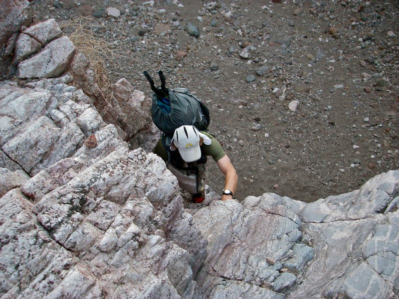
The first team left the hotel at 8pm, crossed the street, then headed up a wash into the surrounding low hills. Other teams followed at 5 minute intervals. Lots of small unmarked roads turn off from the main road that we were trying to follow, and after we topped out in the high plateaus above Boulder City, we got a taste of what the race has to offer. We hesitate in the night about which canyon to follow down to the river, but we choose correctly, and down we go. 4km later we climbed up onto a ridge and met Robert at the first rappel station. I had expected the rappels to have bolt anchors, but this anchor wass just a webbing loop over a large horn which Robert is tending. After a 30' rappel, we climbed steeply down to the canyon bottom again. Some of the downclimbing is very steep going. Christi enjoys her 5-10 shoes with grippy soles. She is the best climber of the group, too, so I nominate her in my mind as the climbing problem-solver of the group.

We travelled through some dripping moss-covered narrow canyons where hot and steaming water seeps from hot springs in the mountain into warm rivulets through which we tread. We worked our way through heavier brush, and then we burst out into the open, the cool moonlit Colorado River ahead of us and steep canyon walls all around us.

Time to packraft. We unpacked our Alpacka rafts and inflated them, put together our paddles, and launched into the Colorado. Moonlight streams down the cliff walls from the almost full moon. The river is peaceful and calm. After 2 miles, we turned into a very small canyon marked by a boating sign next to the water, deflated the rafts, and started to climb. If it weren't for some pink ribbons marking the way, I would have guessed that we were on the wrong track. One section contains a 10 foot wall that is especially tricky, but I managed to overcome it by french-freeing off of Tom's foot as he sits on top of the wall and dangles his feet down for me. After a while, we climbed onto easier terrain, then headed straight up towards the ridge.

I slipped up here, as I had drawn a line of expected travel on the map, but hadn't noticed that the pink ribbons had taken us north of a ridgeline and away from my expected line. We topped out on the ridge expecting to find a plateau, and we found a valley on the other side instead. Tom suggested that we were too far north, but in the dark, I could not quite match up the map with the terrain there either, and I struggled to make our location match the spot on the map where I wanted us to be. We headed in the correct direction in fits and starts, then further confused ourselves by heading up a parallel reentrant than the one we wanted, turned back, turned forward again, turned back. We eventually got back into our game when we found the correct canyon that would bring us to Adventure Canyon, but not after a couple of teams leapfrogged in front of us.

Adventure Canyon is a wild ride. A dozen rappels and several downclimbs awaited us down the canyon. Two of the rappels were pre-set 100 foot long, single rope rappels that burn our hands by the time that we reach the bottom. Other rappels contained just an anchor point and required us to install our own rope, rappel, then pull the rope. In one spot, we arrived at a 15 foot drop that looked sketchy to downclimb, so we installed a rappel over a horn and rapped down, only to find that our rope was jammed in a crack behind the horn. Christi climbed up to free the rope, then downclimbed the route anyways.

We arrived at the top of last rappel to find a traffic jam of two teams in front of us. We were at the top of a minor waterfall that dropped directly into the Colorado River, and figuring out how to
transition from rappeling to packrafting without any place to stage our gear at the bottom was tricky. This is what Robert meant by "problem solving"? A team in front of us was inflating packrafts and lowering them down on the rope - it seemed to take forever. Christi created a sling on her packraft, and when it came to be our turn, she rappeled down with her packraft on her back. Just above the water, she leaned backwards and dropped right into her raft. She hooted with excitement. I went to do the same. Wow! I think that rappeling down a waterfall into a packraft will definitely be a memory I'll keep for a long while. Tom came down last. After a brief struggle with the overhanging lip, he rapped down and onto his back into his raft.

He is a big guy, though. The paddles in his backpack got stuck in his raft somehow, and he felt like he was going to flip over. He looked like an overturned turtle as the waterfall rained on him from above. We unhooked him from the rappel, and while Christi went to pull the rope, I steadied Tom so that he could right himself and get his pack from underneath him. Christi meanwhile yelled that the rope was stuck. She hung off of it underneath the waterfall as her boat slowly filled with water. The rope moved a little, and after more hanging and tugging, Christi got the rope moving freely and recovered it.

Dawnbreak and another hour of packrafting brought us to another canyon which we were to ascend. 94 km of trekking was starting to feel a whole lot longer than the number suggests. However, this climbing was easier than before, and daylight raised our spirits temporarily. My spirits were lifted even more when Christi volunteered to carry the group rope, now soaked and heavy, up the ascent. We topped out at about 9am on a jeep trail that led to manned CP2. There, we dropped off our rope/harnesses, filled up with water, and headed out for the 30km overland "survival trek".

Although we got through the largest ascent before the heat of the day set in, we knew that we were going to spend some hot hours on hills and ridges far above the water. Our navigation was straightforward: stay on a due south bearing 5km to enter a wide valley. Follow valley up to ridge of highest mountain in area. Follow south ridge of mountain down to CP. Although everything went smoothly, Tom and Christi had used up half their water, and I was not too far behind. The temperature reached 100.3 degrees. Tom, a big guy, was quite affected by the heat and began to move significantly slower. We continued on ridges to CP8, took a break under the sunshade, then dropped down to a wash where we picked up a road through flat terrain and easier going for a while. Noone was eating or drinking very well in an effort to make our water last.

We made our final 300 foot climb up to Peeper Pass and took a bearing on the next checkpoint 800 meters away which marked the entrance to the canyon that would lead us back down to the river 10 km away. We reached the canyon to find some shade and take stock of our situation. Tom complained of dehydration, but still had 20 oz of water left. Christi had 5 oz., and I had 30 oz. of water. Tom looked like he was bonking, so we had him drink his remaining water and eat some food. I also gave him my bladder with the understanding that Christi and I could take sips of water from him as needed.

The canyon on the way down was partially shaded in the 5pm sun, and we made good progress, although we eventually ran completely out of water. A mile from the river, we encountered a pour-off that required us to scramble up and around on high, scree-filled slopes. Tom uncharacteristically had trouble here, and even fell and slid a couple feet once. I decided to go for more water, and left my pack with Christi while I took a bladder and ran down to the river to fetch water for the group.

My trip to the river and back, punctuated by 3 rattlesnake sightings, was only half as exciting as the action unfolding up canyon. Feeling faint and dehydrated and out of sorts, Tom worried that he was getting heat stroke, wanted to call search and rescue. Christi attempted to calm him down. She felt him to be cool and clammy rather than hot and dry, so diagnosed him with heat exhaustion. After some discussion about how a search-and-rescue operation would play out, they agreed to push the Help button on the SPOT tracker (which never went through due to the high canyon walls), and they unrolled a packraft for Tom to lie down on while they waited for me to return with water. The packraft was still somewhat damp and the coolness calmed Tom down enough that he took a nap. I returned within the hour with enough water to reinvigorate Tom. Christi headed down toward the river with two packs while Tom and I took our time getting ready and following behind her. It was past dark by now and cooling off.

Tom looked better after more food and water at the river, but he was done for this race. We all agreed to packraft an hour down to manned CP3 where he could exit the course and get medical help if he needed. Coincidentally, his wife was volunteering there. Christi and I left Tom with his wife and paddled to shore where we decided to sleep for a few hours and recoup. We both curled up on the beach in our inflated packrafts and drifted to sleep.

We struggled awake at 3am and shrugged off the travails of the previous day. Rise and Shine! Christi and I headed up canyon and tried to get our heads back around the tasks ahead. We manouvered through the canyon in the dark, topping out into a giant open area just at dawn. Here we followed Jumbo Wash southeast. I could not quite place whether we were in the right wash, but I knew that we would head southeast to a pass, then down to a road on the other side. Somehow when we topped out, we were even closer to the checkpoint than I had expected. Serendipity shines on us.

We dropped down to CP4 where we found one of the many selfless volunteers waiting with jugs of water. He had not seen anyone go by since Dart and Bones had both gone by the previous day. It is awfully lonely out here. From the CP we followed jeep roads for another 10 to 15 km to Rosie's Cafe on Highway 93. I was looking forward to a milkshake, but I had to settle for a ginormous rootbeer and a club sandwich. At Rosie's, volunteers shuttled us to Robert's house. There, we took showers, ate, rebuilt our bikes, and plotted the rest of the course on five maps. Although Robert's house was comfortable, I worked franticly to finish the map work and get out the door. The first third of the mountain biking course required more difficult navigation, and Christi and I wanted to do this part in the daylight. We left at 1:30pm, right into the hottest part of the day.

The bike route wandered between roads and cow paths and other faint trails as we looked for the landmarks identified by questions in our coursebook. Unmarked roads teased us to turn the wrong way, and we spent wasted minutes up a wrong side road early on as we learned the calibration of our bike odometers. The heat was intense, too. Up on a windy ridge, we chose to nap for an hour under the shade of a large bush. Naps never felt so sweet! Slightly rested, we continued on roads past a building that I recognized from our race in 2009. I've been here before! I immediately took the wrong road that headed up a ridge. As the road topped out on "wrong way" ridge, it curved back on itself and headed back down the way we had come, an obvious sign that we were lost. We push-biked off-trail to a knoll (avoiding the barrel cacti) and took a back bearing that confirmed that we were too far east, so we headed west through the desert and picked up the correct road just as the sun set. Now that I recall, I think that intersection was tricky in 2009 as well. Live and don't learn.

Tricky navigation over, we climbed into a low range of hills in the twilight. Our bike lights reflected the saucer-like eyes of nighthawks that liked to rest on the dirt road. When startled, they fluttered in the air around us like little daemons with huge bright glowing eyes. A tarantula wandered onto the trail and stopped us in our tracks in wonder. "Ow, my eyes!" it seemed to say, and covered its 8 eyes with its legs when our headlamps shone too strongly on it. At the crest of the hills an old mine shaft was bored into the mountain. Another team had rested inside here during the heat of the day, but the weather was pleasant now under the stars, and downhills were ahead.

We turned onto a road under the transmission lines, and although we had an expected distance to the next turn-off, we counted the power poles as well: "number two - for me and you; number three - next one's free". We tried to think up rhymes to keep us occupied, as well as to not forget what number we were on. Our memories become shorter and shorter as the race goes on. We found the correct turn despite our rhyming. I had written odometer readings for (almost) every turn, so Christi and I cruised effortlessly through the twists and turns. Later on, we entered the "Flat Zone". Christi had a bike flat, then a flat on the other tire, then I got a flat, all within 20 minutes or so. We each had brought two spare tubes. During the last flat, Christi patched the old tube while I pumped up the new one, so that we would always have a couple tubes ready. This preparation was enough to scare the daemons that plagued us, and we didn't have another flat for the rest of the race.

We followed roads down to Red Lake, a huge desert lake bed. I took a bearing on the checkpoint that was two miles out on the lake bed, and the bearing lined up with Orion's belt. We turned off our headlamps and rode out onto the flat, featureless playa, using the stars as our guide.

Druce and his pickup were at this spot, and we chatted with him briefly while filling up with water. He mentioned that the next section would take us 6-8 hours. It would actually take us 12 hours. Druce would later earn the nickname of "Mr. 6 to 8 hours on the bike". We decided to bring less water than we should have. After an hour nap, we pondered our next move.

The next point was 4.6 miles away across a featureless lakebed. I decided that it was too far to accurately navigate there in the dark, and I picked another point that was closer and had a road to it. We aimed off for this second point. After a mile or two, we came up to several posts across the playa. I slowed down suspiciously, and discovered that there were barely visible strands of barbed wire between the poles. Through this, we came to another fence, then heavy brush. We started to follow the fence, and came to an unmarked road, then another one. I realized that we were effectively lost.

We followed a road west onto the playa again and looked for tracks. Shortly, we found a set of bike tracks that headed on a bearing that suggested they had aimed straight for the next point rather than doing something crazy like we did. At about the correct distance, the tracks fanned out as if they were looking for the point now. I was pretty sure that the point was west of them, as there were three other teams ahead of us whose tracks we had not seen. Christi and I headed west for a while, then turned off our headlamps and peered into the darkness. We could see a vague black rectangle off in the distance, so headed to that. It turned out to be the giant water tank that we were looking for. Lucky us. I felt slightly guilty about using the "back of the pack bike track" strategy to find the point. In retrospect, we should have just followed DART and Bones' tracks right out from the last checkpoint, as they had done this part during the day and could see where they were going. In any case, we found it.

We travelled a torturous sandy road to the highway, then turned south to travel 13 miles of unexpectedly difficult highway travel into a strong headwind. We realized we should have brought more water. We were exhausted before we even got to the dirt road turnoff that would lead us to the 3000 foot climb over Chekum Peak. The Dirty Avocados saved us, however, when they told us about a water faucet at a nearby farmhouse that they had just used. We drank and refilled our bladders for the climb.

The climb sucked. Druce was smoking crack when he rode this if he thought it was 90% rideable. In any case, we pushed our bikes for most of the way up the climb. While we stewed in the summer-like heat, dark clouds and strong winds swirled around the top - I'm not sure which I should be looking forward to. We finally reached the top with our morale crushed and exhausted from the climb and lack of sleep. I tried to ride the singletrack downhill, but just couldn't. My reaction time was so slow, I was afraid that I would bounce off a rock and over the side of the hill. I stopped my bike at almost every switchback or moderately difficult move. I was definitely at a low point. We exited onto chunky jeep road that was much wider and made me feel much less worried about my inability to keep a straight line. I studiously tried to avoid looking at anything I didn't want to hit, and by this method I managed to survive our ride down into the small town of Chloride, AZ. Mountain biking at its worst. We stopped at the market to get a couple ice creams. The store owner there told us "You must be the slow group." Ouch. Apparently, DART and Bones had come through at 2am last night and woken them up.

The ice cream revived me enough to make it to the TA several miles down the road where we could get rid of our mountain bikes forever. Good riddance! Several other teams were in the TA, many of them slower teams that had leapfrogged forward on the course after skipping CPs. Christi and I pulled the foam out of our bike boxes and slept in the shade for a couple hours while other teams cleared out. Then we put away our bikes, ate, and saddled our packs for the next trek as darkness descended.

The first half of the trek was fairly straightforward march in the dark. We slept another hour, dropping our packs and sleeping in the wash where we had stood, then marched along washes and roads for miles. Dogs barked in the distance, and we could glimpse trailers and other remnants of civilization in the distance. We followed the road over a small rise, then downward towards a four way intersection that required us to double back on a parallel road. I cleverly (in my own mind) decided to take a shortcut overland in the dark to this other road, using a bearing and pace count to find our way. We crossed and were temporarily confused by one unmarked road, then wandered through someone's yard and onto another road that abruptly ended. We were caught in suburbia hell, and after encountering a couple more roads, I realized that I could not guarantee our success in this misadventure. We doubled back to our original road, followed it to the intersection, and discovered that the parallel road marked on the map that we had been looking for was actually a very un-roadlike wash. We had been standing right on this wash 20 minutes previous, but too many new roads in the area prevented us from identifying it as the only marked road on the map. In any case, we were back on track, a little older and a little wiser. We followed the wash up to the next CP where a water stash would be for the second half of our trekking leg.

Except that there wasn't any water waiting for us. Confused, we decided to sleep a couple hours until dawn and revisit the issue. Up at 5:30, we searched a wider area and found the water stashed behind an old water tank rather than at the plotted CP 100 yards away. Restocked, we headed out on one of the more technically challenging navigational sections. Daylight is an orienteer's best friend, and we chose a few easily identifiable landmarks that guided us easily to the next marker on a ridge, then dropped back down into the canyon that would eventually take us 3000 feet down to the shores of Lake Mohave.

Christi and I had decided not to carry our rope for this trek. A tricky pour off, however, required us to lower packs on a double runner before downclimbing, and at a larger pour off we downclimbed the right face on chunky, loose rock. We tested each rock before using it as a hand hold, as some of the chunks would break free under pressure. With patience, however, we bypassed the most technical sections with little problem.

The steep canyons gave way to shallow washes and wider, flatter terrain as we moved closer to the lake. We spent several minutes at a local high point identifying the features along the shoreline a few miles away until we felt confident we knew where the next checkpoint would be. We chose a mountain along the skyline beyond it to guide us, then aimed straight there across the rolling terrain.

We both heard the rattle, and jumped back several feet. We had seen several rattlesnakes before, but this one was definitely the Clint Eastwood bad boy of the bunch ("go ahead, make my day"), with the whole front half of his body raised up like a cobra ready to strike should we take one more step in the wrong direction. We chose not to test his resolve, and beat a hasty retreat.

Along the water of Lake Mojave now, we trekked a kilometer along the shore before ducking through the heavy willows to inflate our rafts and launch through a field of semi-submerged snags onto the crystal clear waters. The last CP was somewhere along the shoreline (we had only been given a general area in which it would be), and we enjoyed the pleasant paddling up the coast as we kept a lookout for the marker.

We went further than expected when I stopped to take a bearing on other landmarks. We had gone outside of the range that we had originally plotted; however, we had been given new instructions at the last TA by a volunteer that the CP was now in the "top quarter of the map grid". I had asked the volunteer to clarify, and gotten a response that indicated it was just a narrowing of the range that we had originally been given, but like the game of Telephone, it is hard to know how the instructions were originally given from the race director, and it was obviously not where we had expected. In order to make sure we didn't miss it, we turned around and paddled 40 minutes back to the very beginning of the range, then turned around again and kept much closer track of the shoreline. We returned to our original point and went another 10 minutes up the coast before we saw the CP, about 1 km north of the far end of its supposed range. The extra hour of packrafting was enjoyable though, as it was a beautiful day and we were on the water and off of our feet. We pulled into the canoe TA a short time later.

Then the park rangers arrived. While they talked with Robert down on the beach, I frantically grabbed the canoe gear that we needed and tried to move all of our gear into a separate pile, afraid that they would somehow stop us from leaving. Christi and I collected food and gear, then waited a short while on the opposite side of the penninsula from the rangers. After a while, Robert reappeared, and we asked if we could leave yet. "You can do whatever you want. It's a free country", he replied. We were on our own. We grabbed a canoe and left. We paddled around the small penninsula, past the rangers, and headed up the lake. I tried to look as much as I could like a tourist.

The lake was boiling hot in the late afternoon. And canoeing is difficult and slow. We switched to kayak paddles and saw a huge jump in our speed. After a couple hours, I got out our maps and started to navigate. We had talked about just skipping the canoe checkpoints, but Robert begged us to do them; besides, looking for the checkpoints keeps our minds active during the long canoe. I started to give the coves that we passed names of animals that they most closely resembled on the map. We were aiming for the bull-moose cove, and canoe cp 1 was up the wash that formed its furthest antler.

Arriving at bull-moose cove, we met Way Too Cool who were apparently having better days. They looked mentally fried, and staring blankly at their map, they asked us "Are we close?" when we pulled up. "No, wait, don't tell us..." We turned into the correct wash then headed up a narrow slot canyon. Really cool. We came to a 10 foot climb. Christi went up, then up another short 5.6 bench, then up a rope to the checkpoint. I waited below. We decided not to go up and over to canoe cp 2 as it was getting dark and the climbing seemed very technical. We found an owl feather in the sand as we headed back to the canoe, which Christi took for good luck. Then we looked up to see a screech owl on the rim of the slot canyon talking to us. We listened to it for a short while, then continued back. One hundred yards later, we saw another owl on the rim. Was it the same one following us? I think that it was Christi's spirit guardian, coming to tell her that she was in safe hands. When we got back to the canoe and ate dinner, a toad followed me around. I think that Christi got the better spirit guardian - I'm just sayin'.

Right after dark, I found that navigating the canoe was a bit confusing; however, as the moon rose, we could make out the terrain along the water and our trip up canyon became almost magical. With a glance at the north star I could tell whether we were due north or twenty degrees to the west. The moonlight on the mountains and canyons was just enough to keep us oriented, and the soft warm night drifted over us like a comfy blanket. Off in a cove, we heard the sound of Cat Stevens drifting across the water as a pleasure boating party got started. Moon shadows drifted through my mind.

We pulled into the correct cove for the next set of checkpoints and headed up the wash. I like that when navigating this section, one has to commit to hiking a kilometer up a wash to find the checkpoint. The wash opened up and we followed tracks the wrong way. A line of hills that we thought to be two miles away turned out to be the low ridge that we were looking for, only a couple hundred yards distance. Back on track, we grabbed the two checkpoints and headed back. But wait, Christi forgot her pen. We needed to memorize the four words on the marker stakes. A couple minutes into our return trip, I gave Christi a pop quiz, and she could only remember one word correctly from each of the checkpoints. I found this incredibly funny, and still tease her about it. Our memories are shot after four days of racing and little sleep.

Then the hallucinations set in. I started to lose track of where we were exactly. We decided to push on to the beach where we had exited our first trek, as there was a sandy wash behind that beach that would make a nice bed for a couple hours. The canyon walls, however, turned into dragons and giant figures that were warning me of doom should we enter the steep canyons ahead. I could hardly recognize the cove, as the rock walls turned into spaceships and apartment buildings. We finally turned into the correct spot and stumbled to bed. Ah, sleep!

Friday morning. Windy canyon lives up to its name, and the wind is, of course, against us. Otherwise, the river is peaceful and calm. We can see deep down into the river, where ghostly figures of underwater trees reach up from the depths towards us, submerged skeletons that indicated the river line before the dams were built. We explored a couple more canyons to get the last set of checkpoints. The very last CP was partially blocked from view by rocks, and we wandered by it twice before finding it. As I pointed to say "it should have been right there" and started to reach for my plotting tool, Christi spotted it, exactly in position. Only the finish line remains now.

Two miles until the finish, but a small islet beckons to us. We pull over and tie off the canoe. Christi and I take turns, diving and cannon-balling off into the cool, refreshing water. Cool, clean and refreshed, we are now ready to finish this thing. Willow Beach ahead, we are done.

Tuesday, September 7, 2010

Four Days of Hardrock

I've always wanted to run the Hardrock 100 trail run, but given how hard it is to get into the race through the lottery system, I may never get the chance. Instead, I decided to plan my own run-cation to go run/hike the course in four easily manageable segments over four days. Along the way I would travel 100 miles, accumulate over 33,000 feet of climbing, and summit Mt Handies, a 14er. My dad and Karen signed on to be my crew, and would drive our car to meet me at each stop.

This was the schedule
Thursday: Ouray to Telluride: 16.2 miles, 5500 ft gain, 10150 feet avg. elevation
Friday: Telluride to Silverton: 27.8 miles, 10200 ft gain, 11023 feet avg. elevation
Saturday: Silverton to camp Sherman: 29.3 miles, 9350 ft gain, 11430 feet avg. elevation
Sunday: Sherman to Ouray: 27.9 miles, 8000 ft gain, 11080 feet avg. elevation

We started from Ouray on Thursday. My father joins me on the trail to Telluride while Karen drives the car around. Warren is getting ready to run the Imogene Pass run in a couple weeks, and he has planned to get in a little high altitude training. The Hardrock course follows the same route as the Imogene Pass course from Ouray up to Camp Bird, but then we turn up Yankee Boy/Governors basin and go up and over Virginius Pass at 13100 feet. Virginius Pass is a steep scramble up scree to a low point on the sharp ridge. It is not be very runnable. At least we don't have snow and cornices like the acutal Hardrock race might have in the beginning of July; on the other hand, snow might be softer and easier than sliding backwards on sharp, pointy rocks. The descent into Telluride is straightforward.

My father drops me off the next morning at 7:30am at the trailhead in Telluride for my run to Silverton. He and I have backpacked this section on a two day trip in mid-September last year. We braved constant rain and dodged thunderstorms, and an overnight snowstorm dumped an inch of new snow on us. This year, on the other hand, the weather is perfect: daily highs in the 70s and continuous clear days. As I start my run this morning, though, the temperature hovers near 40 degrees, and overnight it dropped down to freezing in the mountains - I definitely do not want to be caught out overnight.

Praying for a healthy trip, I set out for Oscars Pass on a steady climb to 13,100 feet along roads then trails up a valley behind Telluride's ski slopes. From there, I drop down steep jeep roads, losing most of my hard fought elevation gains, then immediately head up again to Grant Swamp pass. This section, and Grant Swamp pass in particular, is one of my most grueling sections of the run. The upper valley is filled with scree, and at the top, I must climb a headwall of dirt and scree to reach a break in the rocky spires. I've only been at altitude for two days, and hour upon hour of high altitude exertion is slowly depleting me.

Beyond Swamp Grant Pass are picturesque Island and Icy lakes. Here I encounter Warren and Karen, who had hiked up Icy Lake trail to meet me. I shar a sandwich and a moment with them, then I continue on. Crossing a creek on an animal trail, I then follow a traverse across steep hillsides down valley to the next climb. I break out of the woods onto high grassy slopes, where I travel off trail over ridges to another high pass and down into Bear Creek valley, eventually picking up a hiking trail that I follow back down into Silverton. I finish at 6pm, just in time for a delicious prime rib dinner at the Pickle Barrel in Silverton with the family. That was a little tougher than I thought it would be.

The next morning, I become a little anxious thinking about my run. This leg from Silverton to Sherman is slightly longer, higher elevation, and has more off-trail mileage than yesterday. I am unfamiliar with the route, and I also planned to meet my father and Karen at a wilderness campground at the end of the day. What if one of us doesn't make it there? Looking at the frosty ground, I don't relish the idea of being outside at night without a tent or sleeping bag. I pack an extra layer of warm clothes in my pack, and a headlamp, just in case something dire happened.

As I head out of town, I pass the giant canopy tent for the Silverton 6-day, 3-day, 24 hour run that is going on up and down Kendall mountain. This bunch of crazy people is running a one mile loop up and down the mountain, over and over and over. I prefer to travel, and I will hopefully end up in Ouray, where I originally started, two days from now. After a couple brief navigational issues, I find the correct jeep road and head up, up, up to the first pass of the day: Little Giant Pass. The course description reminds me that a slip on the narrow trail cut into the rock here could be fatal; however, the trail is dry and free of snow and easy to travel. After my brief visit to 13000 feet, I drop into Cunningham Gulch, switchbacking steeply down through a scattering herd of sheep in the lowlands, then across the road and up the other side.

The trail up to Green Mountain Pass diagonals up steeply between cliff bands, then follows a ridge into a valley up in the higher reaches of this range. At some point I am supposed to turn left on a vague secondary trail and ascend slopes to a pass, but I do not see the trail. After a little puzzlment, I pull out my topo map and forge out on my own course. I find the pass, then traverse slopes to a 4WD road through Stony Pass. The four-wheelers are out today, enjoying Labor Day weekend. I am quickly across the road, however, and ascend slopes to a small peak at 13200 feet, the high point of the day. A short contour takes me down to Buffalo Boy Ridge.

I have gone only 14 miles in 6 hours, so I am currently on the 12 hour plan, giving me an hour of sunlight left after my arrival at Sherman. This high altitude stuff is killing me slowly, as I find myself walking some of the flat sections above 12000 feet, not to mention all the uphills. However, most of the climbing is over, so I hope to pick up speed in the second half of the day. I try to call my father and let him know how I am doing, but there is, as I expected, no cell phone service.

Next, I drop steeply down a trail into Maggie Gulch. Once in the basin, I again have problems with the course description. After wandering around the basin for a short bit looking for a sheepherder's camp, I give up and strike out on my own again, descending the basin through open fields and light brush to the drainage at the bottom, where I cross a stream and arrive at the end of the 4WD road marking the location of the hypothetical aid station. On this run there are no aid stations, so I carry my food for the whole day with me. I do need to refill with water soon, however. Given the evidence of mining activity immediately around me, I decide to wait until the next stream.

Next, I climb up slopes and intersect with the Continental Divide trail, which takes me easily to the next pass and on into the Pole Creek drainage. The trails are becoming easier to follow and very runnable, although somehow I still manage to follow a trail that disappears on me a short way into the drainage. I can spot the correct trail nearby, and so I easily traverse over to it. Daylight and open spaces makes correcting my course fairly easy. Now I glide along, slowly losing altitude down West Pole Creek basin to the confluence with the main fork of Pole Creek. I hike and occasionally run as I slowly gain altitude up the main fork of Pole Creek.

My last climb is off trail and over the pass into the Cataract Creek basin. Once again, I cannot quite follow the directions of the Hardrock course description, so I bushwhack up to the correct area. I am glad I have USGS 7.5' quads of the area, as I feel confident about finding my way irrespective of the trail description. I work my way through heavy bushes and come out a the pass, where there is still a Hardrock trail marker dangling from a cairn. Hooray! It is all downhill from here.

The last five miles takes me past a few serene lakes, then down Cataract Gulch. The more I descend towards the trailhead, the more well-defined and easy to run the trail becomes. I make very good time, arriving at camp Sherman at 5:30pm, 10.5 hours after I left Silverton. I had spent a non-trivial amount of time on this leg wandering around trying unsuccessfully to figure out the exact course description. Tomorrow will be much easier. Warren and Karen, the great crew that they are, have already set up my tent and are making me dinner. Yum!

Sunday is my final leg. After a delicious pancake breakfast, I say "see you soon" to the family and I set out for Ouray. I make good time up 4WD roads to a trailhead and turnoff to Handies Peak. A small village of people are camped here, ready to climb a 14'er. The trail up Handies is very well established, and I can put my maps away and just speed-hike along, up, up, up to the basin below the peak, up a ramp, up the ridge, then over the top, still on the well-established trail. At least a dozen people are already at the top this morning, and I passed many more on my way up. It is a bit windy and crowded on top, so I take only a minute to enjoy the view, then I turn south and cruise down the other side of the peak into American Basin.

A faint side trail leaves American Basin and takes me over American-Grouse Pass into Grouse Gulch. I lunch at a small lake in the upper basin, then follow an established trail down the valley to a 4WD road. I don't really look forward to the 5 mile run/hike up the road to Engineer Pass on the Alpine Loop, a popular 4WD circuit. Jeeps, motorcycles, and little 4WD buggies pass me in both directions constantly as I continue up the road. The scenery of the valley below is amazing, however, and I can understand why everyone and their mother would want to be here.

At Oh Point (it is named such because people look at the view and say "Oooh!"), I wave at the gaggle of jeepers enjoying the view, then I dive over the edge and into Bear Creek basin. No 4-wheelers are going to follow me here. I skirt a huge herd of sheep that fills the upper basin, picking up a trail lower down that will take me all the way down to the highway six miles away. This trail is beautiful as it drops into a narrow walled valley past a couple old mine sites, then skirts along the walls as the edge drops precipitously down to the stream bed hundreds of feet below. At the hanging valley's mouth, I drop steeply down shale-covered switchbacks to the highway just outside of Ouray.

I travel trails that weave back and forth between the highway and the Uncompaghre River as I descend into Ouray, then I turn onto city streets for the last half mile to the city park. I finish at the gazebo where I started four days ago, take off my shoes, and soak my appreciative feet in the creek. I am home.