Monday, July 30, 2007

Vancouver Island Circumnavigation -- Week 5

Day 29: Keeha Bay to Carmanah Bay

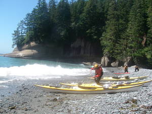
The low tide surf lanuch is very doable. We rounded Pachena Point with some boomers kicking up. One had my name on it, but I barely dodged it. It's a little unnerving getting so close to such huge breakers. We tried to stop at Klanawah River to play on the cable car, but the surf was too huge. We couldn't land at Tsusiat Falls either, although we can wave to the hikers along the West Coast Trail. We were able to land at an Indian Reserve just west of Clo-ose where a guy was living who invited us to stay and camp and have dinner with him. There were also some fishermen there who were also kiteboarders on Nitnat Lake and had come out through Nitnat Narrows for the afternoon. After some brief chitchat, we push on to Carmanah, as I've been talking up Monique's restaurant for days. Luckily, the beach is well protected behind Carmanah Point, and we had no problem landing here.

Ah, Chez Monique. This restaurant is built on the beach with logs and tarps, and is taken down each winter to protect it from the winter storms. Monique serves up burgers and beer to hikers that travel the West Coast Trail from a tiny piece of reservation land tucked in below the Carmanah lighthouse.


Day 30: Carmanah Bay to Sombrio Beach

Chez Monique is even better for breakfast than it is for dinner. We bacon, eggs, hash browns, toast and jam. More hikers come through, and there is a common bond of being way out in the wilderness that brings us all together in camaraderie. Monique's kids are taking orders and working the kitchen while she lounges and chit chats as well.

Boomers and swell kick up strongly in spots on our trip to Sombrio Beach, provoking Scott to suggest a mild earthquake, although a series of undersea shoals is more likely. The big swell is scary and steep as it careens to shore. We stopped at Carmulle(?) Creek, a pocket beach on the West Coast Trail where the surf was difficult but manageable. To get off the beach, Roy and I try a cowboy maneuver, pushing our empty boats out past the dumping wave break and then jumping onto the stern and shimmying up and in. It worked great. We also stopped along the way in a very sheltered Providence Cove and basked on the stones in the sunshine.

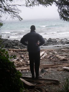
A lot of people are camped at Sombrio Beach, including surfers out on a small reef break. The beach is 500 meters from a road and parking lot, and has toilets and bear cans. We camp on large cobbles that clink like poker chips, away from the more established campsites. Fog and mist come in late evening. We spend some time planning our next several days. The big restriction is figuring out where we are going to camp, something we haven't had to worry about for weeks now. We elect to go with a three day plan for getting to Discovery Island, camping at French Beach and an RV Park just past Race Rocks, then zipping into Victoria for an hour or two on our way. Plans change though, as we later discover.


Day 31: Sombrio Beach to French Beach

We are not planning on going far, so we don't leave until 11am to miss most of the morning ebb. The sky is slate gray. We leave before the ebb has ended, but we catch eddies and a tailwind all the way to Jordan River, making great time. We pull up on a small beach at river's edge and cross a small road to eat at a restaurant called Breakers. Two girls who have just finished the West Coast Trail sit at the next table, catching lunch en route back to Vancouver. When we leave, they run across the road to wave us off.

Four miles on, we make a fairly easy surf landing on French Beach, only to discover that supposed campsites are 400 meters up a trail at the far end of the beach. We camp next to the "No Camping" signs back behind some trees on the hiking trail due to the winds that have picked up. The weather is very overcast and windy, so there won't be many people out on the beach anyways. The weather report says that it is blowing 30 knots at Race Rocks right now. It was a sleigh ride today, and we got off the water just in time.

As we are camped along the trail inside our tents, a boy and his father walk by. The boy asks "why are they camping here??". His father replies: "maybe they were in those kayaks and it got too rough". Good answer. Luckily, noone bothers us this evening. The urbanized world is rearing its ugly head when we have to worry about where we are going to be able to camp.


Day 32: French Beach to Victoria

We got up early and off the beach before people started showing up. It's a long slow paddle up the coast, although we make reasonable time. We look for the petroglyph that Doug Alderson mentions. We meet some hikers on a beach who point us in the right direction. There is a seal petroglyph, and there is also a thunderbird which is a recent knock-off. We make it all the way to Race Passage at 1pm, just as the flood starts. Some of the morning winds have calmed, so it is very easy and pleasant. I had suggested that we might continue onto Victoria, which is now in view another dozen miles away. After overcoming Scott's fears about not getting to the kayak shop in time for him to store his boat, we decide to go for it. Our other option is to kayak a mile down a side bay to an RV park, which is the only other place where we know there is camping. Hmmm. Living the good life in the big city, or camping in an RV park? Let's go to the city.

We catch flood and wind and cruise along across the bay at 5 knots. Today is a beautiful day, and I feel like I can kayak on forever. The harbour is alive with a cruise ship, float planes and harbour tour boats.

We stop in front of the Empress Hotel for an obligatory picture, then head up a channel to Ocean River Kayaks, with whom Scott has spoken about storing his kayak. They are extremely nice. They let us store our kayaks in locked racks and our gear in a shed overnight. Their store has an amazing selection of really good quality gear, too. I bought a new tow belt to replace the one I lost at Peddler's Cove, and chat with the store people about our trip.

We stay at the Traveller's Inn, three blocks from the kayak shop. After showers, we head for an Irish pub for pub 'n grub, then out for ice cream, then we do a little shoppping for gifts. Roy buys Cuban cigars for his girls' soccer coach. Andrew buys more tea than I can drink in a year. Victoria is a charming, bustling town that is worth a visit again sometime.

Day 33: Victoria to Jones Island

No rush in the morning, as the flood doesn’t start until afternoon. Scott leaves us early to catch the bus to Port Hardy, while the rest of us go out for omelets before walking down the street to Ocean River Kayaks to pick up our kayaks and gear. Everyone there is really friendly.

Navigating our way through the tour boats and float planes, we head out of the harbour and head east to Disco (what locals call Discovery Island). We have very favorable eddy currents the whole way, and we end up relaxing on the beach for a good amount of time while waiting for the flood to start. The flood current wraps around Discovery Island and then heads straight up to the shore of San Juan, so even though we are going to be doing a long crossing, the current is going exactly the same way we are.

The only hazard in the Strait when we push off is a tug towing a barge, but it motors on ahead of us. We bounce around a few rips going across, but with no boat traffic and little wind, the ride is quite enjoyable this time. When we start heading up along the shore of San Juan, we really catch the current, and my GPS records 7.5 knots at one point with fairly minimal paddling on my part. We average 4.5 knots from Disco all the way to Roche Harbor, where a disgruntled customs official checked us through customs. Welcome to USA he says with a frown. The flood is winding down, so we crack the whip and jump out into Spieden Channel, heading for Jones Island.

There are lots of people on Jones Island. There are seven other boaters at the CMT site alone, but the people are very friendly and perk up when we say that we have kayaked from Victoria this morning. One guy has had many west coast experiences, and we swap stories about our trips. People start offering us wine, and we happily settle in for our last supper.

Day 34: Jones Island to Washington Park

We are up before everyone else and silently slip out into the water. Our latest plan is to arrive at 3pm at Washington Park. The San Juan Islands seem like home as we wander along the south side of Orcas past the ferry terminal at which I’ve spent so many hours waiting in line during previous summers. We stop in Olga for brunch, tying our kayaks up at the dock and then hiking up to the Olga Art Gallery/CafĂ© for baked eggs with smoked salmon. Roy points out a series of artwork there that Shawna Franklin (of Body Boat Blade) has done, as she is an artist when not kayaking. The west coast seems far away now that we are appreciating fine food and art a few miles from home, but we will be back again some day. A few more miles and we are out in Rosario Straight and heading home.


Tuesday, July 24, 2007

Vancouver Island Circumnavigation -- Week 4


Day 22: Spring Island to Catala Island

I'd really like to get to Catala Island today, but we have to meet Andrew at Rugged Point at 5pm. We head into Kyuquot again to throw away any remaining trash and make a couple more phone calls, then we work our way down Union Island and across to Rugged Point, doing a little rock gardening along the way. We arrive four hours early, but Andrew arrived five hours early. "Onto Calvin Creek!" I trumpet. If we can make it there today, we can get out onto the Hesquiat Penninsula the next day, then maybe to Hot Springs Cove the following day.... After an hour for lunch and relaxation, we head out to Grassy Top Island in the "Fossil Island" group. This island contains a lot of fossils which paleotlogists are studying, but which I find all look like small clam shells. The island itself is an amazingly beautiful island with a protected lagoon formed by other small islets, all a mile offshore. From there, we can follow a chain of islets all the way down the coast to Jurassic Point. Moderate winds and swell from behind us propel us along. It gets very bumpy as we pass outside the breakers over the shoal at Tatchu Point, then we turn and head in for the south side of Catala, Scott leading the way a half mile ahead of us. We find a perfect wide pebble beach with beautiful views, water, sunset, everything. We are in one of the most gorgeous places in the world right now, and noone else is around. I feel like we are early explorers in a way, and we are about to head on into the unknown parts as we head south toward Nootka tomorrow.

Day 23: Catala Island to Calvin Creek

Who would have thought that today would be better than yesterday. I am still on a kayaking high, and the world is beautiful. We paddled over to the east side of Catala to look at a couple caves in the forest behind the beaches, and we played in sea caves along the way. Then we breezed by the Nuchatlitz, a raft of otters greeting us with excitement as we passed by. Wind and waves picked up around Ferrer Point and we had a bumpy ride down the coast. We saw five gray whales feeding along Skuna Bay, the closest coming about 30 yards away. Calvin Creek was a wide open beach with a wee bit of surf. We arrived just as the winds picked up to 20 knots, making further kayaking a frustrating paddle. Scott capsized and rolled back up for the fans, otherwise landing successfully. The rest of us cruised in for a safe landing, agog at the beautiful waterfall. Could things get better than this? Just as we hit the beach, a float plane circled and landed on the beach, dropping off three women with their surfboards and gear, then took off again. Ah, surf babes. Things are looking even better.

We swam in the pool to our heart's delight. Roy and I paddled our kayaks around in the pool. I even pulled out my air mattress and jumped in for a bit. I had boasted that I would paddle my air mattress around the Brooks Penninsula if the weather were good, but Calvin Creek was a lot more relaxing for such a stunt.

I tried hiking into the woods up around the waterfall, but the brush was too thick, and I began to worry about getting eaten by wolves.


Day 24: Calvin Creek to Escalante Point

It's a shame to leave such a beautiful spot. We'll come back here some day. Heading out, Andrew got pummeled by surf, getting water down his neck, a common occurance. I like to call the venting necks on our touring jackets "neck funnels". We stayed right near shore around Bajo Point and avoided the reefs that extended miles offshore. An eagle is picking at a carcass on the beach. Past Beano Creek at Callicum Creek, Andrew and Scott went inside the break and Andrew got slammed again by waves, this time capsizing and rolling back up. More water down his shirt.

We had a lot of fun exploring some nice sea caves between Bajo Point and Maquinna Point. A lot of the caves are huge and fairly safe to get in and out. One low-ceilinged cave would reflect waves of the back with a big thunderous splash, and we tested how far we could go in before surfing out on a big reflecting wave.

Coming around Maquinna Point, we were humbled. We had paused briefly behind a well protected rocky outcropping, and I was just about to continue on when the hugest set I've seen on the trip came through the rocks in front of us. The waves curled like Hawaii Five-O and crashed into the rocky reef that made up the shoreline. Four waves came in. I don't know if I could have made it through one of those waves even if I were paddling straight at it, and if we had been only 10 yards ahead of where we paused, our broken kayaks would have been littering the rocks. Yikes.

We stopped at Yuquot / Friendly Cove, but the guardian there said that there was a $10 landing fee if we wanted to walk around, so we headed back to our boats. We crossed Nootka Sound over to Escalante Point, at which point south winds picked up to 12 to 15 knots, so we decided not to continue further down the penninsula. We will get up early tomorrow instead. Escalante Point has a huge mile long beach and we are very happy to go sunbathing for the afternoon.


Day 25: Escalante Point to Hot Springs Cove

Yesterday’s afternoon winds have subsided and we can sneak inside the various reefs up along Estevan Point. At one point we heard some hikers yelling. We thought they might be trying to signal us, and after they let of some sort of firecracker, we went in to investigate. We needed to navigate through a series of breakers which caused us great excitement. At one point I turned around to see a big set coming in, and just barely got turned around and over the wave before it broke. Roy said the hikers looked fine, so we headed back out again. Maybe they had shouted and set off a bear-bang stick to scare off a black bear or something.

Going around Estevan Point, we were inside the reef in water as shallow as 3 feet. The tide was high (8 feet), so we would have been on dry land at low tide.

We stopped at Mathalaw Point, then crossed across the mouth of Hesquiat Harbour to explore the sea caves west of Hot Springs Cove. There is a gigantic cave an hour west of Hot Springs Cove that has a sandy beach inside. I tried cruising up onto the beach but was caught by a surging wave and sidesurfed onto the beach. Getting out was even trickier as the surging wave ran wall to wall. I managed to drag my boat down, jump in and get the sprayskirt on before being sucked into the surf, and after a battle with a couple breaking waves, I was back out again.

I was weary when we finally made it to Hot Springs Cove, and had several grumpy moments as we paddled around looking for a good campsite. We eventually camped at a place that Scott had camped 12 years ago, but which we later found out was Indian Reserve land (although we weren’t bothered).

After eating dinner and watching all the tourists leave in their little speedboats, we paddled over to the government dock to hike 30 minutes on the boardwalk through old growth cedar out to the hot springs, where we would share the springs with sailboaters and other campers. The hot springs ran over some rocks, creating a natural shower, then into three pools, the lowest which had sea water coming in. There are probably more pools at lower tides, but tonight it was fairly crowded. After a refreshing soak, we paddled back to camp just as the sun set.


Day 26: Hot Springs Cove to Vargas Island

We saw several whales today. In the second spot, near Cow Bay, there were several speedboats filled with tourists stopped at a respectful distance watching the whales. We had seen some sea planes flying over this spot earlier – they might have been spotting the whales for the tour boats.

We traveled along the outside of Flores and Vargas islands. Fog came in, reducing our visibility to 100-200 yards and making our voyage a little more exciting. We pulled out the GPS to get a bearing and distance to a waypoint marked on our chart and tried navigating through the reefs for a while. I almost got hit by a breaker in the fog. After a half hour, the fog started lifting, and we were pleased to see that we were heading in the right direction.

After stopping in Cow Bay for (foul-smelling) water, we headed over to Vargas to try to get as close to Tofino as we could. We came across a nice large beach on the south side of Vargas with several other beach-goers camped there. I talked with one girl from Nanaimo who was circumnavigating Vancouver Island as well. She was on week six and had five bear encounters in her camp, including at Guise Bay and Escalante Point.. She has gotten giardia, anaphalactic shock and a few other nasties that make her trip sound like a trial. She and her boyfriend were at the Brooks Penninsula when the big storm hit (while we were in Port Hardy), and they had to spend three days there.

Lots of sea planes and small motorboats go by, taking tourists on excursions.


Day 27: Vargas Island to George Fraser Island

Today is going to be a long day, so we got up early and paddled an hour into Tofino, arriving at 7am. Nothing in Tofino is open at 7am, so we spent some time walking the city while waiting for shops to open. At a popular bakery, we have french toast and cinnamon rolls for breakfast. In the next few hours, we pick up our food packages at Tofino Sea Kayaking, sort our gear, make phone calls, and buy groceries and gifts. Andrew and Scott make stops at the liquor store, and Roy mails off a package of stuff he doesn’t need any more.

We headed off at 11:15, and made good time. We passed Florencia island, which is a reasonable spot to camp, and we made it all the way to the Uclulet peninsula. With the wind picking up and hoping to find a place to camp, we checked out the George Fraser Islands off the coast of Uclulet. These islands had a few sheltered beaches, though very difficult to access at low tide, but they would do.


Day 28: George Fraser Island to Keeha Bay

Low tide in the morning leaves us with a very long slog over snail encrusted rocks to get off the beach. Across Loudon Channel is the Broken Group, a very popular kayaking destination. We passed Clarke Island and stopped on Benson for a short hike, then headed across Imperial Channel to the Deer Group. We briefly search from some archaeologists who are supposed to be working on Diana Island, as the warden at Robson Bight had told us they were friends of hers and might give us a tour. We found their boat, but no one was home.

Scott knows a place north of Cape Beale where there is an old long house, so we head over there (it is apparently on an Indian Reserve and requires permission to go there, although I didn’t know that at the time). In the trees, we found the site of a couple longhouses, with corner posts still standing and trees growing over and out of the beams. Everything was very grown over, but exciting nevertheless.

It’s a bumpy ride around Cape Beale. There are HUGE boomers with massive water being pushed around. I feel humbled by the sea, as no skill could master these waves. Around Cape Beale, we enter Keeha Bay, which requires a small surf landing. We land near a creek which is nice for doing a little bathing and wash. Some people built primitive structures out of driftwood. One has a sign saying “Keeha Bar and Grill”. There are some people camped further down the beach. I saw a mink playing down along the surfline in the evening.

Tuesday, July 17, 2007

Vancouver Island Circumnavigation -- Week 3

Day 15: Cape Sutil to Guise Bay

A misty morning welcomed us as we slipped off the beach and rounded the cape. Cape Sutil is the northern most point on Vancouver Island, yet not anywhere near as famous as Cape Scott, its big brother to the west. We stopped at the tip of the cape to look for petroglyphs that a guidebook had mentioned. We found a couple very worn faces at high tide line on a large rock overlooking the beach.

We spotted a couple whales working the shore at Nissen Bight, probably grays. There are also two to four sea lions following us. They appear occasionally of to the side of our boats, but every once in a while one splashes ten feet off of our sterns. I am a bit unnerved as this continues to happen all day - the sea lions follow us for 10 more miles, all the way to Cape Scott. Don't they have something better to do?

With no wind and low swell, we decide to round the Cape, even though we are at max ebb. There are some tide rips further off the cape, but we tuck in close and spend some time rock gardening. The swell is big enough to make this quite sporting, and the tide is high enough that we can explore back into the slot channels below the Cape.

We eventually work our way down to Guise Bay, the first large bay on the west side of Cape Scott. It is Experiment Bight on the north side by a 1000 yard long canoe drag, an area of low sand surrounded by a beautiful meadow. In particularly rough conditions, one can portage one's kayak around the cape across this section. In the late 1800s and early 1900s, some Danish settlers tried to live here, but the lack of a protected cove and lack of a promised road to the site eventually drove them away.

A path with boards laid down as if it were a wagon trail leads up the lighthouse through a forest. We can see the three islands that compose the Scott Island group, five miles out. We imagine kayaking out to these islands, but that is a serious undertaking for some other day. Tomorrow we will head south and east for the first time, back towards home.


Day 16: Guise Bay to Cormorant Point

The weather today was good but windy and sporting, and very frustrating for me. With his skeg, hull length and natural ability, Scott always stayed way ahead of us, while I floundered in the quartering wind. I finally gave in and used a rudder stroke every fourth stroke to keep me from broaching. I'd really like to have a skeg right now. When the weather is fair, winds tend to build from the northwest, which will propel us down the coast. Tomorrow's forecast calls for a southeast gale, though, and the swell height off of Brooks the next couple days is 8 to 11 feet -- big weather ahead.

Day 17: Cormorant Point to Lawn Point

Wanting to cross Quatsino Sound, we got up at 4am to beat the gale. There was absolutely no wind crossing the sound until the last half mile, then winds kicked up to 20 knots abruptly. We are cold and wet as we stop for a snack at Restless Bight. I managed to rip the gasket on my drysuit (the party hasn't begun until someone rips a gasket). Roy gave me the idea of putting my Paclite top over my drysuit, then putting my balaclava hoodie on top of that to seal everything up, so no need to pull out the duct tape just yet. This setup also kept me plenty warm on a fairly miserable day.

We battled 20 knot winds to Lawn Point, and conservatively decided not to push on when we would be fighting the winds directly. We stopped at 1pm.

Today was not my day for several reasons. I was not be able to find my bear bags this morning for five minutes until Roy came over and pointed them out to me. I had put my food in spectra Ursacks and tied them to a log, but then I couldn't remember which log and was just not seeing straight.

Not to mention, my boat floated away. By fortuitous circumstances, disaster was averted, however. Scott had put his food in his boat and turned it upside down, saying that if something tried to get at it, we would be able to hear it. Then, Roy started hearing a banging in the night, as if some critter were trying to get at Scott's boat. He looked out, but Scott's boat was fine. Then later, he heard the banging again, and a screech. Again he looked, but Scott's boat was fine. The other boat was fine, too. But wait, weren't we supposed to have three boats? The other one was floating in the bay, 50 yards away. Roy called out the alarm, and I said that whosever boat it was would have to get it, until I realized it was my own. We should have been more careful tonight, as it was the highest tide of the month and the logs on which we place our boats where themselves floating and bumping against each other (which was causing the banging sounds Roy had heard).

This evening I listen to the rain coming down. I set up my siltarp as a vestibule for my tent, and am quite comfortable. I can hear the wind blowing over the trees, but our camp is tucked in the lee of the wind. Welcome to the west coast.


Day 18: Lawn Point to NE Brooks

High tide last night rocked a few more logs near the tents. Roy had marked the afternoon high, then using a cup of water as a level, eyeballed where a two foot higher tide might go, and we were supposedly safe. We got up at 4 am again.

We rounded Lawn Point and entered Brooks Bay, one of the most beautiful bays on the west coast. The Brooks Penninsula looked like the Misty Mountains, and later, the mist descended onto the bay to reduce visibility to a half mile or less.

We saw a tarp set up on First Beach (aka Beach of the Lotus Eaters), but we didn't stop, and headed out to Fourth Beach, the furthest reasonable spot on the penninsula. Our camp is right by a river that looks like good surfing practice at the entrance. Sandpipers are running up and down the sandy beach with the waves, eating bugs and flotsam. They all turn as one and race back up the beach as a new wave comes in. I bathed (ahh) in the river and did my laundry (ahh), erroneously thinking that we would have dry weather at some point to dry them out. In a fit of twisted logic, I ended up wearing my clothes in order to dry them. The weather report says tomorrow's winds are going to be 20 to 30 and swell 8 to 10 feet, so we will wait until Friday to go around the Brooks. Rest day! Actually, I've gotten accustomed to long days, and the last couple days have seemd like days off, almost.


Day 19: Rest

It rains all day. My tent leaks in spots at the seams with the silnylon floor, so I use my pack towel to keep it dry. I venture outside once or twice and take naps. Scott reads his book. I'm worried that Roy has gone missing until he finally makes a brief appearance out of his tent in the early afternoon. I'm pretty comfortable considering it has been raining all day and all week. I'm ready for sunshine, though.

Scott and I make a brief foray down the beach. We had to cross the river which was up to our knees. Bibs work nice for this sort of stuff. Back to the tents for another nap. We call Andrew on the satellite phone and let him know that we are going to be going around the Brooks tomorrow. We agree to meet him at Rugged Point on Sunday at 5pm, three days from now, so he has a little time to get himself in position.

Day 20: NE Brooks to Nasparti Inlet

Today is the big day. Swell height is still big, but forecasted winds are down. The surf is still big coming onto our beach, so we aim to launch out of the river. Roy, the last one in, has trouble with the hydraulics pushing him onto the rocks, and his boat gets battered a bit. Luckily, he knows a good fiberglass repair guy back home. After a few aborted attempts off the beach, he moves his boat into knee deep water, jumps in, and paddles out through the waves without his sprayskirt on.

The wind out at Cape Cook was mild, maybe 7 to 10 knots. We paddled out to Solander Island where the puffins flew and the sea lions bellowed. The channel to the north of Solander was constantly breaking with white water and the sea lions were looking at us warily, so we opted not to go around the island, instead just staying on the inside. Mist came in and dropped the visibility to a half mile, which was about the distance offshore we were as we contoured around the penninsula. The swell was a little too big to venture in closer. We made no stops. We went very wide around Clerke Point where there were a lot of breakers into kelp beds.

Day 21: Nasparti Inlet to Spring Island

Today is a sightseeing day, as we keep ourselves entertained while allowing Andrew a little extra time to get into position. After a little rain this morning, the weather clears and it turns into a beautiful day. Our stormy days are finally over, and as it turns out, we will only get a sprinkling of rain once during the next two weeks of beautiful weather.

We head for the Acous Penninsula where we see the burial island with the skull and canoe again. Scott points out a location where there are lots of shrubs and small trees above a beach and suggests that as a likely village site due to the atypical nature of the flora. It suggests that the old trees were cleared at one point and different species grew back. Checking it out, we found the long house we were looking for (go Scott!) as well as two fallen totem poles.

We met a solo kayaker who was headed out towards the Brooks. Roy scoffs at the kayaker without immersion clothing and with paddle float on back deck, suggesting the guy would not know how to use it in the wind/waves. We are such elitists. Anyways, it's lucky that people don't flip over very much***.

We visited Battle Bay next, where there is a nice beach and a river coming out. A beautiful grassy meadow surrounded the river for a distance inland. Perhaps the river gets flooded with brackish water at high tides so no trees grew there.

Next on our tour guide is a quick trip through the Bunsbys. We continue on to Thomas Island for a nostalgic visit to our crash landing there during last year's storm, but we don't land this time as it is too marginal. Then, on to the Mission Group.

Realizing that on Sundays the stores could be closed in Kyuquot, we decide to pop into Kyuquot this evening, arriving at 5:30. We find that Charlie's is closed for the season (perhaps permanently), but the general store is open for another half hour. We have a junk food feast, make a few phone calls to loved ones, and watch the native kids play tag and dive off the dock.

Heading back to the Mission Group, we discover that Aktis island is an Indian Reserve with houses on it, and that Kamils island has a nice looking beach, but the meadow above it ends up being a graveyard. We head to Spring Island. There are some fishing camps on the islets around Spring, and a couple camps in the large cove, but we find a spot to call our own. We are not used to sharing spots with other people.

***: Upon arriving home, however, we discover that this kayaker had been reported missing the following week, and that he and his kayak were never found.