Tuesday, August 31, 2010

Trioba 33 Hour Chelan Adventure Race

I've been impressed with the quality of races that Trioba puts on here in Washington state, and was looking forward to Trioba's 33 hour "midnight start" adventure race that would take place in Chelan this fall. I attended as part of Team Mergeo: our team was Miles Ohlrich (me), Roger Michel, Andrew Feucht, and Beth Brewster.

We discovered that the gear drop was an adventure in itself when our team arrived together in Chelan Falls. Staff directed us to drop off our kayaks and continue to the next drop-off spot in Entiat. As we drove, we tried to guess what the course would look like, but we never suspected when we dropped off our bikes that we would next be going to Plain, at the far end of the Entiat crest. I suspected that we would need to be transported somewhere, and when we arrived in Plain to get our maps and final directions, we discovered that we would be boarding a bus for an hour and a half bus ride to somewhere back in the Chelan area.

The map work was somewhat daunting - we copied checkpoints onto 10 maps that covered a 100+ mile point to point race across northern Washington. I feared that at least a few of the roads on the USGS maps that we received would not exist any more, and that there might be a few new unmapped forest roads that would keep us guessing, making our navigation a little trickier. We used as many supplemental maps as we could to identify the most appropriate routes in the two hours that we had before we boarded the bus.

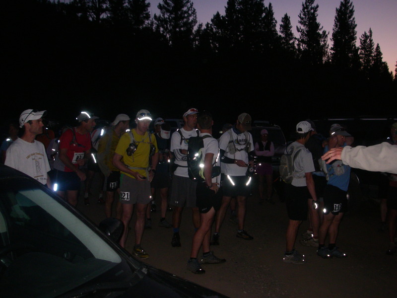
We rested as much as we could while the bus carried us on the 1.5 hour trip back to a park in Chelan for the midnight start of the race. There, we were given an orienteering map of Chelan containing 12 marked check points (CPs), and in "street scramble" style, we raced around town to visit the CPs in any order, answering a question on our answer sheet about some object at each location. We turned in this answer sheet at the finish location just outside of town at the base of Chelan Butte. During the next leg, we trekked through the Chelan Butte Wilderness Area, mostly off trail. We travelled through rugged scrubland with occasional thick sagebrush and scattered trees and bushes. The initial climb from Chelan up to Chelan Butte was incredibly steep, and we found ourselves sliding backwards on the steep gravelly terrain as we struggled up the 2600 foot climb. Ahead of us, we could see the bobbing headlamps of the two teams in the lead, and behind us, a line of small glowing orbs snaked up from the bottom of the hill. The moon and stars danced above us.

Once on top, we tested our night time navigation while traversing across ridgetops and valleys formed by years of erosion in this arid land. We leapfrogged past another team when we dropped directly down to a fire road that was longer but easier while they sidehilled along a high slope. We also chose routes to save our feet from blisters this early in the race: running ridgetops and going straight up/down slopes are good shortcuts. Contouring across slopes is hard. A lot of routefinding choices presented themselves in this rugged terrain. I enjoy trekking navigation though, as I can continuously consult my map while still keeping a good pace. I tripped over more than my share of bushes and fallen logs, however, while I had my face stuck in my map.

The sun came up as we traversed a ridge with views down to the Columbia River to the east. The next CP we found secreted inside an abandoned mine, its entrance barely visible above a stream of tailings. Daylight now, we worked our way through the last couple CPs, through an apple orchard on the edge of town, and ended at the Chelan Falls City Park at our kayaks.

We launched into the Columbia River for a 20 mile tour down to Entiat Park. Waterskiers dotted the glassy slow-moving river like bugs. Orchards hugged the shoreline wherever flat land snuck in between rugged cliffy slopes. Two CPs were placed on small islands in the river along this leg, and the chance of missing them kept me somewhat focused on where we were, although the warm morning sun teased us with thoughts of napping. Roger and Beth in the rear kayak temporarily drifted into a dream state, and Andrew and I felt a stiffer resistance to our paddling as the tow rope between our boats went taut. In general, though, we all kayaked peacefully and happily, resting our weary legs for the stages to come.

Off the water at Entiat, we each grabbed a quick sandwich from the gear bin while we changed into our biking gear. We started with an easy ride up Entiat River Road, and then we turned up Crum Canyon road where we climbed gradually, then more steeply. We had all left our bikes at the road and hiked to a CP on a small hilltop when Andrew and I heard Beth scream behind us. Apparently we had disturbed a nest of rattlesnakes, and five baby rattlesnakes stared her down and slithered at her. Beth has a snake phobia, so she threw Roger in front of her to ward them off. Apparently, the smell of Roger by itself was enough to defeat the snakes. We were not taking any chances, however, and gave the area a wide berth on the way back from the CP.

We continued to climb, eventually attaining a pass where we picked up some singletrack. Finally, we get to ride some trails! The singletrack quickly turned into a rocky rut through the scrubland. While cursing the race diretor, we rode our bikes through the scrubland to the side of the singletrack because it was easier. However, after a short while, the rut disappeared and we glided down along a ridgetop. The race director was forgiven. We picked up another section of singletrack shortly thereafter that was absolutely divine. As I sped through wide graceful turns along the smooth dirt down a ridgetop, I cast off my prejudices that mountain biking should somehow always include technical hard-as-nails terrain. My spirit soared into the sky, but only too quickly we dropped back onto the fire road again. In front and above us was Steliko fire lookout. Quickly dispatching the short climb, the checkpoint, the view, and the descent, we dropped down the fire road to the town of Ardenvoir, then up Mad River road to the next transition area (TA).

At this point, we could choose to do a "pro" course option, which was available to any teams that arrived before 9pm. It was now 6:30pm. The pro course contained only two CPs: one nearby up a steep, steep 1000 foot climb. The second CP was 3 miles along the ridge beyond that and did not look fun at all. DART had taken 3.5 hours to finish the pro course, and team Verve arrived back at the TA while we were still there, also having taken 3.5 hours. These were the two fastest teams. We had heard that the next team behind us was a couple hours back, so I decided that we should just get the first CP. That way, if another team did arrive before the 9pm cut off, they would have to get both CPs in order to beat us, and even if they did, they would be facing the real possibility of not getting to the finish before the 9AM cutoff, risking disqualification. Andrew pled, however, that we go to both CPs, as he was insistent on doing the whole, whole course. I assumed temporary insanity on his part and ignored his plea.

We climbed a slope up to the pass to get the CP, then decided that we would go down a different, easier looking way. The slope is always more gradual on the other side of the valley. Anyways, the easier way was at least as difficult as the way we went up, but we finally managed to get down the gravelly scree slope, push our way through the thick brush-filled, dry creek bed, and get back to the TA again.

We enjoyed the hospitality of the volunteers as they poured us coffee and cup-of-soup, and we relaxed in the TA for much longer than we might otherwise would have. We were enjoying ourselves, and we didn't feel the need to push the pace. The navigation during the next section was going to be the trickiest of the whole race, and our main goal was to stay on track and get up over the Entiat mountain range to the finish line before 9am without losing our way or getting overcome by sleep monsters. Ready to face our second night without sleep, we got back on our bikes and headed out the forest road up along Tillicum Creek, then up Indian Creek.

A couple kilometers up Indian Creek, we came to a decision point. I had researched this particular spot extensively in the two hours before the race and pulled up some info from several different extra (more recent?) maps. We could go one of three possible ways. Going right, we could traverse a possibly decommisioned road for a kilometer up to a junction. At that point, there were two roads, but the slightly shorter one was also probably decommissioned, so the longer road was a possibility. On the other hand, we could originally go left from Indian Creek and take another road that looked reasonable but longer. However, maps seemed to indicate a lot of other roads in the area that could potentially confuse us a lot in the night, and I was skeptical of this route. I had chatted with one of the race officials in the last TA and shown him our map, and from some casual comments he made, I got the feeling that going right would be more interesting (for him or for me??). So we went right.

The possibly decommisioned road was definitely decommisioned, but a bike trail followed it the whole way up, or at least followed where it would have been had it not been washed down the cliff to our right. In a few spots, there was so little room to even put a trail that we teetered over the edge of the dark abyss. And given that the road had already washed away over the edge, I was not too confident about what still remained, especially as we had already raced for 24 hours and had cobwebs in our brains. After making it through all the particularly scary parts, however, we heard Roger shout from behind us and yell for help as we went through a short stretch of road dotted with saplings. I'm not sure how he fell, but I found him splayed on the ground gripping a fallen sapling with his head dangling over the edge of the cliff and his bike
on top of him. He wasn't sure in the dark exactly how close he was to the edge, so he decided to sit tight and not move a muscle until he got some help. Having survived a cliffhanger, we continued on. At the junction where the good road was supposed to start, we were pleasantly surprised and elated that it did just that. No surprise is a good surprise.

I got a flat. It was just a slow leak, but after pumping it up, it went flat again 15 minutes later. We decided to stop and fix it. Halfway through fixing it, I discovered that the tube that I had brought with me had a Schrader valve instead of a Presta valve. Then I discovered that a Schrader valve wouldn't even fit through my bike's rim. Du-oh! Ironically, we had already fixed one flat this race, and Andrew had discovered that he had also packed a tube with a Schrader valve. We borrowed Beth's spare tube to fix my flat, noting sardonically that the only two tubes we had left were the wrong kind. The finish line started to look a lot further away. At least I had my old tube which only needed to be pumped up every 15 minutes. I took out the small thorn in my tire before I installed the new tube. I hate it when I forget that step.

The next two checkpoints we could reach by taking a singletrack almost straight to them. How hard could that be? We never saw the singletrack. We followed the road to its high point a couple hundred feet higher than the missing trail, then bike-whacked along the ridge to the shallow hilltop where we located the checkpoint on a rocky outcrop. After this, my feeble brain turned to mush as I was still confused about the missing trail, but Roger stepped in and guided us down the far ridge, which turned rideable lower down as if we were on a very old abandoned road (the trail?). We reached an intersection of two logging roads where the map indicated the trail continued on the other side. Where the trail was indicated, we did find an old road through the thicket that was so overgrown that mature trees were growing through the middle of it, and we could only identify it as a road because the forest was even more impenetrable on either side. After exploring it for 20 yards or so, we decided to come up with an alternate plan.

Roger says "If we had the map to the south of this one, we could see if these two roads connect...". And we did, and they did. I had not bothered to look for alternate routes previously, because the direct (yet non-existent) route was so obvious. Problem solved, we contoured around Sugarloaf peak to the other side and headed for the CP on the summit.

At Sugarloaf, we said hellos to the cold and lonely race volunteers there and prepared for the long, freezing pre-dawn descent. I had to stop two more times on our way down to put every last piece of clothing on that I own - I am so glad that the scattered thunderstorms did not catch us in the night, as I am still somewhat dry at least. We dropped 2000 feet down a forest road to French Creek, then switchbacked onto a long windy forest road that would eventually take us
to the last CP and then to the finish.

Sleepmonsters started to sneak out and grab for us. Roger looked at Andrew and asked Beth, "Who is THAT?" with a serious face. "That's Andrew. He's on our team, remember?". Roger rode his bike into the ditch. We plied him with caffeine, and after many more minutes of unsteady weaving, he was awake and back in the game again.

I had difficulty keeping track of where we were on the map - my short term memory was fading. I stopped every few minutes to verify where we were on the map, relying heavily on my altimeter watch. Only one more checkpoint. We dropped down to the 2400 foot level and leveled off - check. We followed the road through a left turn - check. Road on the right - check. Now the CP would be ahead of us at the next intersection right before the road starts a gradual descent. We travelled for a longer while than I expected. The road was not descending yet, so I wasn't too worried. In fact, it was ascending a little bit. Then it turned 90 degrees to the south. What? I think we're lost.

We cannot be too lost, however, as team Manny's had just joined us, and they are similarly confused. We scratched our heads and looked at our maps, and Roger, who had been asleep on wheels not too long ago, pointed out our exact location. Apparently, part of our intended route had been decommisioned, and we had unknowingly continued on a somewhat parallel road to the east with similar characteristics. All we had to do was keep going forward, and we would loop around and connect back to our original route shortly. Onward!

With dawn rising, we pushed forward and easily found the last CP along the road five minutes later. We continued with team Manny's down to the paved road, then followed it as it meandered over one last ridge before dropping into the town of Plain. Two more miles on the road and we were back at the finish line and the lodge. Trioba staff had just put the eggs on the grill, and breakfast was waiting. Success!

We finished in 30 hours and 35 minutes, and we reached all of the checkpoints, including one Pro-course checkpoint. This was good enough for 3rd place.

Sunday, July 18, 2010

Devils Backbone

With a name like Devils Backbone, I expected the run to be difficult, but it took a little more out of me than I thought. I had heard good things about the run from Matt Hart, a strong ultra-runner, so when Chase asked me in January if I wanted to go to Bozeman for the 50 mile trail run, I signed right up. It was a good thing, too, as the mid-July run, which allows only 30 solo entries due to Forest Service permits, filled up in February this year.

Tom McGoff Hayes confirmed our entries and told us that "this is not a normal trail run. You will be carrying more weight since you will need food and water for at least 5 hours (more likely eight to ten hours) until the one and only aid station. You will also have to feel confident navigating mountain ridges and meadows with no ribbon showing the way... This definitely should not be your first 50 miler." Not to mention, most of the trail was higher than 9000 ft above sea level, making it even more difficult for us low-landers.

Chase and I drove out together to Bozeman on Thursday and crashed in the living room of his friend Peter for the long weekend; Peter also graciously provided us with a beaten up old tandem bike to ride around town so that we could take in the sights. The sun beat down on us with temperatures above 90; Saturday was going to be a little cooler, however. I tried my best not to burn to a crisp before then.

We attended the pre-race meeting on Friday in Tom's backyard, where I sized up the competition. Two guys from Utah, Jay Aldous and Leland Barker, had both finished in the top 5 at Hardrock in previous years, and were the contenders to win. Another runner, Christian Johnson, had run Devils Backbone last year in 10:30, which was my goal for running this year, so I thought I should watch for him and try to tuck in behind him. Tom gave away a bunch of prizes from sponsors to all the attendees, fed us a pasta dinner, and gave us a few pointers about where we could go wrong on the totally unmarked course the next day. He provided some hand-drawn maps as well that showed key turns; I also had topo maps that I had printed out from his website, so I felt pretty confident about staying on route.

Chase and I woke at Saturday morning at 3:30am and fueled ourselves up with breakfast and coffee, before heading out the door to drive for 45 minutes up to the Hyalite Creek trailhead where the race started. Just as dawn broke, Tom started us off and pointed us down the unmarked trail, which climbed 3500 feet in the first 7 miles to the top of Hyalite Peak at 10,300'. Immediately into the run, I could not keep my breathing under control, and settled into as relaxed a pace as I could given the altitude. Leland, Jay and Christian all immediately disappeared around a turn ahead at a solid run which I knew that I could never match. Five minutes into the race, I had already gotten dropped by the fast guys.

Chase and I ran together as we powered through the climb at a good, steady pace. He was looking strong, and when he stopped for a quick bathroom break, he managed to sprint back up the hill to catch up with me. We entered the bowl below Hyalite Pass to see the several hundred foot tall snow slope that we would have to climb to reach the pass. The front runners were already gone, and Chase kicked steps up the slope to reach their tracks while I followed in his footsteps. We looked to see runners behind us hiking slowly up the slope like little ants. Sidestepping the cornice at the top, we were over the pass.

On the way out, we summited Hyalite Peak and grabbed a poker chip from the bucket at the top to give to the race director at the turnaround point. The peak was only a few hundred vertical feet out of our way, and we were quickly up atop it, then back down to the trail that snaked southward along the ridge as far as our eyes could see. Only the occasion snowpatch on a north slope hindered us; the ridge was almost completely snow free. Rocky trails, on the other hand, hindered us, and the altitude definitely did as well.

The Devils Backbone ridge lasted forever. We didn't have much perspective about how far we had gone based on our map. Ridges led to ridges, and the ups and downs slowly ground away at us. The ascent and descent seemed so much more difficult than mere numbers would suggest. We both suffered from lack of acclimitization, and even the milder ascents seemed daunting. My stomach started to protest, and I didn't feel like eating anything.

I imagined that we would reach the aid station/turnaround point at Windy Pass cabin after 5 hours or so, but the five hour mark came and went. I ran out of water so I borrowed some from Chase, who seemed to be drinking much less than I was. Another 10 minutes went by and we passed the front runners returning from the turnaround, looking strong. We descended off the ridge and pulled into the cabin at about 5:25 or so, far slower than expected. I decided to take it easy on the way back and try to get the most enjoyment out of the race rather than try to push too hard and suffer.

I loaded up on water at the aid station: a full 100 oz bladder and two 20 oz hand-helds, then headed back out, waiting a few minutes to take some pictures though while Chase caught up. We started hiking back up the hill. Such a moderate ascent, but we were beat. On a very runnable downhill, I had sudden GI pain and peeled off to the side of the trail to relieve my discomfort, losing Chase down the hill. After I had resolved my issues, I continued on, and found Chase coming back to look for me, worried that I had twisted an ankle or something. Then Chase started to have his own issues, vomiting in one case after gagging on some electrolyte drink.
We were far away from anywhere now, and the only way out was to keep running. We slowed our speed down a notch and kept plodding along. A strong wind blew across the ridge, teasing our caps from our heads; however, it kept us reasonably cool and dry as sweat evaporated instantly from our skin in the sunshine.

When we finally passed Crater Lake (a small stagnant pond), Chase bemoaned that we still had "two more maps to go". I tried to encourage him that most of the climbs were behind us. We saw nobody ahead of us or behind us. We felt alone on an interminable series of ridgelines. Hyalite Peak eventually came into view, a thin ascending line crossing its flank to the pass that marked the trail we would follow. We attained Hyalite Pass almost 11 hours after we started, and gazed down the steep snow slope on the north side of the pass below us.

The race director had told us to take a flying leap at this point, so we did. The snow was soft in the afternoon sun, and we glissaded easily to the bottom of the bowl. Reinvigorated by the cold snow and the 3000 foot descent ahead of us to the finish, we perked up and started to run like we really meant it. Chase thought that we might break 12 hours at one point and we attacked the descent with renewed vigor until the 12 hour mark had passed, then we settled into a comfortable pace for the last 15 minutes to the parking lot. A couple volunteers were lounging at a camping spot in the trees, and let us know we could stop running now. Whew! After 12 hours and 14 minutes, we were certainly glad to be done. That was a hard but beautiful race. Now pass me a turkey, cheese, pickle and mustard tortilla wrap, please. I'm hungry.

Monday, July 5, 2010

Yukon River Quest

The Klondike gold rush of 1897 found prospectors streaming up the coast to Skagway or Dyea, Alaska. From there, they hiked over Chilkoot Pass, down to Bennett Lake, and then they built rafts to float the Yukon some 500 miles down to Dawson City, located at the confluence of the Yukon and the Klondike. Andrew and I heard of a fabulous race called Yukon River Quest which gave us a similar experience, albeit a little more modernized. We decided to go for it.

Yukon River Quest starts in Whitehorse, Yukon (about 50 miles downstream from the Bennett Lake system), and ends in Dawson City. Our goal was to travel down this 460 mile stretch of the Yukon river as fast as we could. Andrew and I paddled a double kayak; others also chose to paddle canoes, voyageur canoes (holding 6+ people), and single kayaks (they get my respect). Everyone started at noon on Wednesday (June 30), and needed to finish in Dawson before midnight on Saturday night, 84 hours later. However, with mandatory rest breaks at Carmacks (7 hours at milepost 200) and Kirkman Creek (3 hours at milepost 362), we had 74 hours on the water to complete our task. Except at Lake Labarge, a 30 mile long lake a few hours out of Whitehorse, the Yukon river was flowing at a reasonable clip, so our main goal was to stay on the water as much as we could and paddle with reasonable effort.

Our first goal was to get to Whitehorse, however. I drove to Vancouver and caught a flight to Whitehorse on Air North, where I relaxed amongst the amenities that this town of 25,000 had to offer. While small, this town contains two thirds of the inhabitants of the Yukon; Dawson City ranks second largest at about 1,500 inhabitants.

Andrew drove up. He really wanted to bring a fast kayak, and because we had not signed up immediately, the rental companies in Whitehorse had only barge-like boats left for rent. His kids had studied the Gold Rush in school, and so he brought the family and turned the trip into a "fun-filled family vacation road trip", at least so much as a 4000 mile roundtrip drive through barren wilderness can be called that. Our rental from Popeyes Marine and Kayak Center fell through (don't ever rent from them), so we scrambled for an available boat, and we ended up buying one on Craigslist from a place near Nanaimo, with Andrew to pick it up on the way up to Whitehorse. They listened to "Call of the Wild" book-on-tape along the way to get themselves in the appropriate mood for the Yukon.

Together at Whitehorse, we shuffled gear, went grocery shopping, and attended pre-race meetings and gear checks. Come Wednesday, we place our boat along the riverbank next to 75 others, and we waited for the start in unforgiving cold and rain. While temperatures had been in the 70s under a blaring sun all week, Wednesday brought grayness, wetness and coldness. I put on my gortex bib, paddle jacket and gortex hat. I was happy that I could wear them without overheating.

The horn sounded and the race was on. We ran 200 meters across the park to our boats, then pushed off into the Yukon to start the race. I had never been in our boat before, and I discovered that I needed a little practice with the new-fangled rudder system. We almost took out a photographer standing on a submerged sandbar before I veered out into deeper, faster water. I tried to draft the person in front of me, but I zigged and zagged and could not control the turn of my boat. The voyageur canoes came up behind us like semi trucks, and I veered out of their way. Many other canoes and kayaks shot past us on their way down the river. We lagged. I'm sure I'll figure out this whole rudder thing in a few more hours. We have lots of time to practice.

For three hours we travelled downriver to Lake Labarge. As we made our way onto the lake, the wind built up two to three foot wind waves that quartered us from behind. The kayak zigged and zagged and we started to successfully surf a few of the waves, especially after I tightened the tensioning straps for our rudder. Now in our element, we elatedly passed several teams ahead of us. We made one quick stop along shore to retension the rudder straps, but otherwise we planned to stay in the boat. We passed a couple more teams at 9pm at the end of Lake Labarge who were changing into their night clothes. Our gortex bibs were fine for the night, and we had cagoules to throw over us if we got a little too chilly, which we eventually did.

The Yukon twisted and turned snake-like through the Thirty Mile River section, a 30 mile stretch between the end of Lake Labarge and the confluence with the larger Teslin river. I felt like we were moving slow, although we were making a reasonable effort. I convinced myself that our boat must be slow, and that made me feel a little better. The current always looks better on the other side of the river, and I spent a little too much time wandering back and forth across the river to find the fast current, which never seemed to be there once I arrived.

As we rounded a curve after the Teslin, I saw my first beaver. Only 10 yards away on the bank, it looked like a furry basketball. On three more occasions in the trip we saw beavers along the edge of the river, all gathering small branches and twigs for their beachside cottages. We never saw a single deer, elk, moose or bear, which surprised me a bit. Beavers own the Yukon.

We followed our laminated charts as the river curved this way and that way. We had twenty pages of charts to get to Carmacks, and we seemed to go more and more slowly through them as twilight came. While the light never faded past twilight in the midnight to four AM hours, it still took a toll on our senses, and we continued to grow sleepier as the morning hours crawled past. Andrew took a catnap in front to reinvigorate himself. I tried raising the rudder so that Andrew could steer while I dozed, but we promptly turned sideways and rammed the shore. Note to self: back person needs to steer at all times. How dismal.

At our lowest low, we stopped in order to quickly switch places. I tried to nap in front, but I could not relax, as I felt I was going to pitch sideways into the water. We stopped again to switch back. However, this extra movement plus a few coffee beans woke me up enough that I could keep going without falling asleep. We finally pulled into Carmacks exactly 24 hours after we started, hurt and tired.

Volunteers helped us in Carmacks by setting up our tent, drying some of our clothes, and filling up bladders with water. We ate burgers, milkshakes and french fries at the canteen, changed clothes, mindlessly rushed around doing tasks I cannot remember, then went to bed. I could not sleep at all due to a horrible pain in my left shoulder, but after some ibuprofen, aleve and melatonin, I calmed down and slept for four and a half hours.

We arose early and got ready to leave exactly seven hours after we arrived, which included drinking another milkshake. We resupplied with food and left a few extra unneeded things in our Carmacks bag, which would get shipped on to Dawson for us. After a quick gear check by the authorities, we went down to the dock and launched back onto the water for another 18 hour spin until the next rest stop. Another double kayak was only seven minutes behind us; we felt some pressure to keep up our pace to prevent them from catching back up.

On the water, my muscles and tendons complained much less than I had expected, and my fears subsided from the previous night of being unable to continue. Time flew and soon we came upon the first of two rapids: Five Finger Rapids. We stayed right as instructed, and with a few bumps we were through. Looking back, the other channels also did not look too bad, either, so conditions must have been miild. A half hour further on, we sidestepped Rink Rapids by also going right. These were the only two sets of rapids that we needed to worry about, and they weren't much. A more prevalent danger, however, was gravel bars that dwelt just under the surface of the river. We occasionally ran into strong side currents that pulled us over very, very shallow bars and threatened to ground us if we didn't paddle hard to get away from them.

We travelled past Hells Gate Slough stretching out in channels to our right while the main current shot quickly along the left bank. Shortly thereafter we passed Fort Selkirk, a historic trading post that was abandoned in the 1950s when the Klondike highway bypassed it and Yukon river traffic died down. At the checkpoint here, we called out our team number as we passed. Another team on shore played with their gear, and we quickly left them behind as we cruised along in the 5 mph current.

Many islands now dotted the Yukon river, and channels and sloughs weaved between them. Although we typically followed the main channel, we occasionally darted down small channels that cut more direct paths around a curve when the main channel swung wide. In general, we discovered that the shorter path was usually the better path.

After 18+ hours and only one five minute stop along the way, we pulled up at Kirkman Creek, a primitive campground without road access that was the site for our second and final rest break. We filled up with water in the stream, ate soup and sandwich, and then spread our sleeping bags out on the lawn for as much rest as we could get during this three hour stopover. Five minutes later when it started to rain, we moved into a couple of tent shelters that they had provided, although the rain splashed through the mesh of the tent and soaked my bag before the storm cloud passed. I did manage a good solid hour of sleep. We ate some very expensive cheeseburgers and got back on the water exactly three hours after we had arrived. At this point, another double kayak was 20 minutes behind us, and a solo kayaker and solo canoer were only a few minutes ahead of us. We felt reinvigorated.

Seconds after we got on the water, a squall came through and a storm dumped on us. I threw on my cagoule. The solo canoer had pulled to shore and we lef t him behind. Shortly thereafter, the solo kayaker ahead of us decided to take a shortcut through a sandbar, and we left him behind as well. He was navigating solely with his GPS, which seemed fairly difficult. Andrew and I each had a detailed river map, and together we came up with a plan on the most efficient course down the river. Alone, trying to look at a map on a 4" by 2" screen, I would have been much more confused about which islands were which and what channel went where. Andrew and I started doing "tempo intervals" - we paddled reasonably hard for 20 minutes every hour - so that noone behind us would be able to catch up again. We never saw another paddler again until the end of the race.

A couple more squalls came through, along with thunder and lightning. We battled a strong headwind for a time, and it reminded me why double kayaks are called "divorce boats". Every lift of Andrew's paddle brought a windblown splash to my face. My hood up and my cap down low on my head, I gradually fell into a repetitive head-tipping motion in order to block the spray while taking occasional peeks at the map to keep us on track. We had just passed the confluence with the White River, and gravel bars and submerged trees peppered the river. We could hear the grit and gravel grinding against the hull of the kayak, and the water was opaque and churning. Lightning struck again, ahead of us. I became a little worried.

The river turned in the opposite direction of the thunderstorm, however, and gradually grew deeper and less angry. The current moved us quickly along, and before we could count to a billion, we saw the Moosehide Slide marking the hill above Dawnson City. Although I joked about arriving at Dawson when the bars closed at 2am, the skies of the "midnight sun" looked like a Seattle afternoon. We pulled into Dawson City in fine spirits, changed out of our wet gear, and headed to our hotel where Andrew's family was sleeping. We'll come back and pick up our kayak later. It's time for bed.

Monday, June 14, 2010

Hiking the West Coast Trail - Vancouver Island

Kathy has always wanted to hike the West Coast Trail, so we put it on our calendar. Although we had picked out a date, we waited until a couple of days beforehand to actually make the decision to go in order to make sure that Kathy was finished with the work that she needed to do, and make sure the weather didn't suck.

I checked the weather last week, and although rain was forecast for Tuesday, Wednesday, Thursday, it was light rain and the skies cleared later in the week. Kathy finished her work. We green-lighted our plan to leave on Tuesday to drive to Port Renfrew, then catch the Wednesday morning shuttle over to Bamfield to start our trek. I booked our shuttle with West Coast Trail Express (trailbus.com) online, and reserved a spot on the Port Angeles to Victoria ferry. We can't make (and don't need) reservations for the WCT until June 15th, so we planned to get our permits when we arrived.

I had high hopes for fancy food-making opportunities on this backpacking trip, but with our last minute preparations, I fell back to the old standbys of couscous or macaroni&cheese for dinner, oatmeal for breakfast, and typical snack foods for lunch: nuts, cheese sticks, molasses cookies, bars, dried fruit, salty snacks, salami and naan. I had made some jerky, dried pasta sauce and dried veggies for my aborted kayak trip earlier in the year, so we brought those as well. I did mix up some hot and sour soup mix to have with dried mushrooms and hopefully some fresh kelp.

We arrived in Port Renfrew early on Tuesday evening and checked out the local hotels. We chose the West Coast Trail Hotel which has nice rooms and super extremely comfortable beds. They also let us leave our car at their hotel, which solved our last logistical problem.

We ate at the Coastal Cafe, which I cannot really recommend. Kathy tried to order the salda with salmon, at which point the waitress remembered that they were out of salad, salmon and steak. I had a burger, but they were out of buns. They did have a pasta salad which was really not very good. After dinner, we went back to the hotel and packed our packs, then listened to the huge downpour of rain that started. Better to get it out of the way now while we are sleeping inside, I thought. In the morning we ate a great breakfast at the Port Renfrew Hotel (same owner as West Coast Trail hotel), then caught the shuttle bus at 8:30 for our trip to Bamfield, along with 8 others.

The shuttle arrived in Bamfield at 12:30pm, and after we had all checked in, the park rangers gave us a presentation which included what to do in case of a tsunami and other barely useful information. Our permits were incredibly expensive - $125 or so, plus another $32 for the two ferry crossings. Paperwork all done, Kathy and I got onto the trail ahead of everyone else, except for one old guy who had skipped the presentation entirely as he had done the trail 16 times. The first section of trail to Michigan Creek is very easy and straightforward, and we averaged maybe 4 km/hr. We continued along the beach to Orange Juice Creek (KM 16), another couple kms further, and stopped at a small creek where we pitched camp. We had the whole beach to ourselves, and had not seen anyone except Old Guy who had camped at Darling Creek a KM further back. It had rained in the morning on the bus trip, but otherwise the weather was cloudy but fair.

The next morning, we woke up to a very light misty rain. We took our time and travelled to Tsusiat Falls (KM 25) by about 1pm, where we stopped to pump water (water is fairly clear and have just purification drops and no pump would have saved weight). We wanted to go further, but the ferry at Nitnat stopped running at 4pm, per the park ranger, and I didn't know where we'd go if we got there in time in any case. We could have gone a few KMs up the beach, but decided to relax and stay near Tsusiat, maybe a few hundred yards down the beach. We became very lethargic. We didn't even cross Tsusiat creek to properly look at the falls. We napped in the afternoon. We worked on a crossword puzzle. We decided to do a long day to Carmanah on Thursday, and went to bed early.

The skies cleared on Thursday (and stayed bluebird for the rest of the week!). We were up before 6am and walking by 7:30 am. We saw mink, oystercatchers and harlequin ducks. We arrived at Nitnat Narrows at 9:45am, where the Ferryman came over and picked us up in his skiff and brought us to the other side. We decided to stop at his dock for a bit and have a soda and share a salmon and baked potato breakfast - yum! Rejuvenated, we were ready for our push on to Carmanah Point where we would have another meal at Chez Monique this evening.

There are not very many camping spots after Nitnat, as the trail passes inland through several First Nation IR lands, and does not reach the beach again until after Clo-ose. Kathy and I were worried a little about the tides making beach travel more difficult, so we spent even more time inland after Cheewat River instead of on the beach. We wore ourselves out by the time we arrived at the Cribs beach, and so we had to take a short nap before continuing on. Our pace really slowed at the end as we climbed up over Carmanah Point. We descended the brand-new ladders to Carmanah beach and crossed paths with the two workmen who had just built them. They were coming back after a few beers at Monique's before heading home - they probably lived on one of the IR lands that we had passed through.

At Moniques, Kathy and I each had a cheeseburger and a beer, then another beer and another. Monique sure can talk. Old Guy showed up and they spent the time conversing while Kathy and I put on our listening ears. After dinner, we headed on to Carmanah Creek, which was completely deserted when we arrived, although another group did arrive just before dusk. This was our favorite spot. A group of harlequins played at the creek mouth.

Although Monique said it wasn't possible, and how she knew because of all the hiker's reports she got, we decided to try to hike to Campers Creek on Friday, 17km further on, through some of the toughest parts of the trail. We had the advantage of a morning low tide, so we cruised from Carmanah to Walbran along the exposed coastal shelves and along the beach, and we crossed Walbran Creek along the beach rather than hike inland to use the cable car. Walbran is a really nice spot too, so we soaked up some rays for a while before moving on.

From Walbran, the trail heads inland, but after a few initial ladders, the trail is not that heinous from there to Logan Creek. Logan Creek has a nice suspension bridge. Then comes more ladders, and then the infamous Mudpits of Despair.

In order to transcend the Mudpits of Despair, you must become One with the Mud. Kathy and I did our best to avoid the deep pools of shoe-sucking mud, but every five seconds we were hopping from one precarious perch to the next, and this went on for several KMs. We both had gortex socks on, which kept our feet clean and dry as long as we didn't submerge them more than 10 inches into watery mud; however, at least half the mudpits were bottomless watery pools of slime in which you might see the tip of a hat or backpack of previous hikers who had become succumbed to the murky depths after the slightest distraction. We were taking no chances.

Gortex socks, by the way, are absolutely necessary. With them, my wool socks stayed clean and only slightly damp. Without them, my feet would have been wet, dirty slabs of meat for the entire trip. There was a lot of mud, every day.

Our will shattered, Kathy and I stumbled out of the Mudpits and descended into Campers. There we found .. people. Lots of people. It was Saturday night, and everyone and their mother decided to camp at Campers. We found an alcove in the trees dirtied by old campfires and set up our tent, at dinner by the creek, and fell into bed. I'm sure that the party went on all night at the score of tents out on the beach, but we did not hear it, luckily. We decided to wake up early again so that we could catch the low tide at Owen Point.

Kathy stared me awake at 5am, and we both decided to get an even earlier start than usual. We rode our last cable car across Camper Creek just before 7am and headed out to Owen Point. The mud was much more pleasant today, the tides were favorable, and we were in high spirits. We arrived at Beach Access A and headed down onto the shelves exposed by the low tide. I promptly fell on my butt on the slick rock. And again. Maybe this wasn't so fun. After a couple false starts, we got out onto less slimy rock and cruised the shelves and tidepools on our way to Owen Point. And the surge channels. I now understand why people could die here. We approached one narrow channel in the rock which was less than 3 feet wide, and seemed quite jumpable if I hadn't just fallen on my ass a couple times already. However, looking down, I saw the ocean water 20 feet below us, and I realized that you were basically hosed if you slipped and fell into the channel. You'd basically be in the ocean with 20 foot walls on both sides, getting pummelled by the occasional wave before you succumbed to hypothermia or drowning. Luckily, a float in the trees above the beach marked a scrabbly path through the bush to get around the back of the channel, which cut deeply across the shelf all the way to where trees grew on the upper slope. We worked our way around other channels and gullies carved into the shelf, and we arrived at the "sea caves" of Owen Point proper. This is basically a couple tunnels/arches through the rock that are neat to explore when the tide is out.

Next came the bouldering section. The beach gradually disappeared to be replaced by ever larger boulders, and required us to climb over boulders the size of Volkswagens to avoid the super-slippery sections down near the incoming tide. Most of the boulders, however, were a few feet across and generally non-slippery, so we could "boulder skip" through this section in a reasonably straightforward manner, albeit always wary about the possibility of a twisted ankle. In the boulder section, we met a film crew who was hiking the trail with helmet-cameras to record their trip and eventually do a DVD and a new guidebook. They gave Kathy a short interview. We're famous!

We took a short break at Thrasher Cove, which is a very pleasant spot when it is deserted, such as at mid-day. Thrasher Cove does not have much of a beach, however, and the only tent sites are back behind the beach logs during high tides. From here, it is a several hundred foot climb up ladders and steep trails to reach the intersection with the inland trail that heads back to Gordon River. Kathy and I still felt good, and so we headed out for what the guidebook described as "the most technical trail section".

It turned out not to be much more technical than any other section of trail, and was very hikeable. It did, however, have a lot more ups and downs than other sections of trail. Our packs, however, were light, and so we flew down the trail, passing dozens of people coming in on their first day. Most of them looked exhausted and unhappy and had huge packs that didn't fit right. One group said that they were travelling 1 KM/hr on this section. Kathy and I got to Gordon River in 3 hours 15 minutes and were quite happy with how easy this part of the trail was compared to our expectations of it. Your mileage may vary, however.

At Gordon River, we met a solo hiker who had gone back from Gordon River to resupply and was heading back to do the WCT again. What people will do to avoid having to pay for a shuttle, I guess, but I definitely did not want to think about traversing the Mudpits of Despair again, at least not for another 10 years or so. Another group of college students had recently gotten off the ferry and were taking a self-portrait at the trail sign with a ginormous SLR camera. Kathy and I raised the float to let the ferry operator know to come get us, and settled in for a well-deserved post-hike soak in the sunshine.

Sunday, June 6, 2010

Trioba Sprint Adventure Race in Capitol Forest

Saturday May 5th was National Trails Day. We celebrated by going to do the Trioba Sprint Adventure Race down in Oakville, WA. Glenn Rogers and the Trioba crew have put on a couple great local Adventure Races last year and we expected more of the same.

Andrew, Roger, Heather and I planned to drive down to Oakville Friday night and camp at the rodeo fairgrounds where the Trioba HQ was situated for the weekend. Packed and ready to go, I got a call from Roger that he had acute food poisoning and couldn't make it. I relayed Roger's predicament to Andrew and Heather. Heather was having a tough week and decided to stay home as well, as fame and fortune were only truly awarded to the four person co-ed teams that participated, and we would probably not have a full team. Andrew and I shuffled some gear and headed on down as a two person team, fame and fortune be darned.

We crawled out of our tents to a bluebird morning, and found that many teams had arrived during the night. There was now a sizable crowd for the race, about eighty people on two dozen teams. We picked up our maps at 6am and got to work planning our route, which was fairly straightforward. I copied a couple of road and trail names onto our Trioba maps from the Capitol
Forest map that I had brought with me before putting it back in the car. Outside maps were not allowed once we started the race, but we could use all of our resources ahead of time to help us plan our route and assist our future navigation.

Andrew and I went to stage our kayak gear at the kayak put-in a mile down the road, and our bikes at the kayak take-out 7 miles after that. The Chehalis was flowing at several times its normal volume, but was still a reasonably mild river with only class 1 rapids and a few snags. We made it back just in time for the pre-race meeting. Glenn informed us that teams would get bonus time for picking up aluminum cans (30 seconds each) and shotgun shells (5 seconds each). I salivated at the thought of getting a BONUS for picking up cans. I have a somewhat compulsive tendency to pick up aluminum cans, so I definitely have been training for this particular skill set, and I was ready to go. I am glad I brought my larger backpack along.

At the start, we followed a horseback rider out of the rodeo grounds and ran a mile down the road to our kayaks. Andrew and I reached the kayaks near the front, and with our well-placed boat, we were second on the water. Andrew set the tone for the day by running into the water up to his knees while getting in the boat. Let's not worry about getting our shoes wet, shall we? We quickly passed the only boat - a canoe - in front of us, and we had the Chehalis to ourselves.

The water was moving at a reasonable speed, and we kept a steady pace as we tried to stay in the faster current around the occasional gravel bar and snagged tree in the water. I discovered that my kayak paddle was feathered at 100 degrees instead of the usual 60, but the wing paddle has some funny locking mechanism that was hard to get undone while we were cruising down the water, so I just decided to go with it. At one point, the current took a strong left around a large log pile in the middle of the river. We almost went right, but Andrew warned me to go left, which was the better choice. I heard that at least a couple other teams flipped while on the water, and I imagined that this log pile might have taken a bite out of some of them if they weren't paying close attention.

Andrew and I got off the water at the Porter boat landing ahead of the crowd and attempted to transition to our bikes. Andrew accidentally yanked his pants down while taking off his spray skirt, to the shock of the spectators. After a quick apology, he joined me as we yanked our bike shoes/helmet out of the bin, threw the kayak gear in, grabbed our bikes and were off.

From Porter, we followed the Porter road and C-line up, up, up to the Mima Porter trailhead. I was a little faster than Andrew on this part; however, instead of employing the traditional bike tow to help even out our pace, I rode a little bit ahead and looked for cans. When I found one, I jumped off my bike, grabbed and smashed it, hopped back on my bike as I slid the can into a side pocket on my pack. At this point I was a little behind Andrew and then raced to catch up, as our team was required to stay within 30 meters of each other. We were still in the lead, but Castelli was slowly closing in on us.

At the Mima Porter trailhead, we transitioned to singletrack. The trailhead was at a "road end" blocked by a downed log, and the singletrack initially headed the wrong direction for 50 yards or so. I was confused about which way to go for a few seconds before we headed up the singletrack. Apparently, the first four teams went the correct way, but many other teams continued on the decommissioned road, heading who-knows-where.

Along the Mima Porter trail, the CPs were fairly straightforward. I hadn't spent too much time looking at the map ahead of the race, although apparently I should have. Verve followed a short road section and got ahead of us, whereas we crossed the road on the singletrack, continued a few hundred yards, then crossed back across the road. Forest roads are much faster on bike than dirt trails. We caught up with Verve and passed them. Verve passed us again when they stayed on a road whereas I got back on the singletrack a little early. Peteris is a great map reader and knows how to squeeze out small gains by optimal route choices.

To make matters worse, the map board mounted on my bicycle loosened up. Mounted on my handlebars, the board normally stands straight up and allows me to read my map while biking. However, now it occasionally wobbled during heavy bumps and rotated sideways. I decided not to stop to deal with it, as it was still somewhat functional.

We caught up with Verve again at the Transition Area before the trekking section, and we all set out on the trek together as a "super team" of 6 people. Andrew and I stayed with Team Verve until we got out of the singletrack trails system and back on the road. Then we moved about 100 yards ahead of them so that we could pick up the occasional can that we saw. Feeling a little guilty, I pitched a couple cans back on the road for Verve to pick up, but by and large, we came out well ahead on the bonus time by being just a little bit in front here.

At the next CP, we had to double back and then bushwhack up the hill to a higher forest road. Perhaps I should have been watching the terrain more closely as we came in and paying less attention to cans. In any case, I decided to pick an animal trail up the ridge through salal early on. Team Verve continued further back to a mudslide section that was very steep at first, but fairly clear up to the higher road. Andrew and I foundered a bit and lost a couple minutes to Verve.

At the next CP, I made a navigational choice that cost more time. We went a ways down a logging road in order to bushwhack up a steep hill to the CP, whereas we could have done a smaller bushwhack up to a trail that went up the ridge. As running on the road was really no faster than running on a trail, but bushwhacking is far more difficult than running up a trail, we should have gone for the ridge trail. We also overshot the CP a little bit and had to double back. Verve was somewhere ahead of us.

When we arrived at the TA where we had left our bikes, a special task was awaiting us. We were instructed to carry a 70 lb bucket of gravel up a trail to a mud pit and dump it, then come back. I like the idea of doing trail work in the middle of an adventure race. Andrew and I shared carrying the bucket up the trail and dumped it. Team Castelli was fairly close behind us, heading up with their bucket as we were coming down, maybe a few minutes behind us.

Transitioning onto bikes again, we now had a lot of fast downhill on forest roads as we headed back out of Capitol Forest. Andrew was faster than I on downhills, as I started to get scared above 30mph on gravelly roads. At one point, Andrew asked me which way to go. Which way? I didn't know there was a route choice here. My map did not show the intersection, so I picked a road (the correct one) based on a general idea of the geography. Castelli apparently picked the other road, then got confused as to where they were, and spent an extra half hour reorienting themselves, leaving them lost in the weeds, so to speak.

At the next CP on a hilltop, I punched the CP while Andrew picked up cans. Then we did another quick search of the area and found a few more cans. Don't throw away those "can" minutes! My backpack was getting full, though. We raced down the logging road to the next CP, and saw Verve exiting as we turned onto the spur road to the CP. They were only a few minutes ahead of us - sweet! More cans. Double sweet!

I made a bad navigation choice by switching my map board to the next map before we were done with the previous one. We just head west, double back to the east, then head west again on a main road, and we're onto the next map. How hard could that be? It wasn't hard at all; however, when we got to the main road, I started to track us on the new map, not realizing that we still needed to go at least another mile before we got onto the new map. When we arrived at a campground at a curve in the road, I thought that we were at a turn off at the further curve in the road, and we spent a few minutes being confused before I figured it out. Duh. Adventure racing is not always about going fast. It's about going to the right place.

We found the correct turn off down the road, and crossed a bridge over the stream to find the second-to-last CP. A trail supposedly continued on from here, but heinous brush covered a grassy sapling-filled decommissioned road, with an occasional tank trap thrown in. We pushed our bikes up the road while I rechecked the map. It sure looked like the right way on the map, but did not feel very fun at all. We came to a mud slope with a rope up it. I crawled up the slope as I carried my bike one handed, then helped Andrew up the incline. After a quarter mile or so (which felt like far longer), we got through the fun forest and back onto a real road again.

Down to the forest boundary and the last CP we sped, then through a couple neighborhoods on paved roads and back into Oakville. We crossed the finish line back at the rodeo fairgrounds only 6 1/2 minutes behind Verve. We pulled cans out of our backpacks and shotgun shells out of our shorts as Glenn counted out our bonus time. We had collected 16 more cans than Verve did, so got an extra 8 minute bonus, pulling us ahead by half a six-pack. We win! Verve won the four person co-ed, however (the real prizes only go to 4 person co-ed teams) and did an amazing job of navigating and keeping their four person co-ed team on target. Peteris wrote up a few good notes about the navigation. Glenn and his Trioba friends did a really great job of putting on a quality race. Congrats to everyone!

Food, beer and bonfire followed. Andrew and I couldn't stay for too long, and had to leave when the party was only just starting to get going. I'll definitely be back next year, though for another excellent race and an excellent time.

Monday, April 26, 2010

Whidbey Island Circumnavigation: Take 1

Andrew thought we should try kayaking in the double kayak that we plan to use for Yukon River Quest, so we rented a Seaward Passat and set out on Sunday to attempt a circumnavigation of Whidbey Island, a trip of almost 100 miles. We were originally going to leave at 4pm on Saturday (which would have caused its own slew of obstacles, e.g. Deception Pass at midnight anyone?), but we decided to leave Sunday morning instead after Andrew developed some conflicts. The marine weather forecast for Sunday was optimal: light winds (under 5mph). Leaving at 5:30am, we caught a rising ebb that peaked shortly over an hour later in Admiralty Inlet. We cruised up the coast of Whidbey, letting our heads swell as we easily achieved paddling speeds of 7 to 8 mph. By the time we took a paddling break shortly before 10am, we had already covered more than 28 miles at an average speed of almost 7 mph.

But alas, after ebbs come floods, and after our break, we struggled to find the magic touch that we had all morning. Had we started earlier, we would have cruised all the way past Partridge Point before the flood came. Somewhere beyond Partridge Point, ebb and flood currents switch (ebb goes south, flood goes north), although currents are vague and inconsistent in this area all the way to Deception Pass, and we never got a boost from the flood as we thought we would. We struggled slowly all the way to Deception Pass, arriving there at 3:15pm (9hr45min,50 miles).

Deception Pass has its own peculiar currents (hence it has its own separate chart), and it begins to ebb an hour and a half before the rest of Puget Sound. So, when we finally arrived, we had missed slack current by an hour, and a strong ebb current was going against us. I estimated it at 5mph. Getting to the pass itself was not a problem, however, as there were some strong back eddies that we could travel up in order to get close to the pass. At this point, Andrew and I dug our paddles in and went for it, eddy hopping our way up the pass in 20 to 30 yard sections before tucking back in against the cliff wall where we were protected from the force of the current. We saw dinner-plate (and larger) sized whirlpools go by. We worried that if we did not time ourselves right poking the kayak out into the current, we might hit a whirlpool and spin ourselves around, to get spit back out of the pass. As the minutes ticked by, the current was only getting stronger. We pulled out our extra stores of effort that we had been saving for the last 9 1/2 hours and struggled through, and we eventually broke out into easier water on the other side of the pass. Whew!

Of course, by easier water, I mean that the current was maybe 2mph against us, for the next three hours. Paddling upstream is not so high on the fun list. The fun-o-meter registered right down there about the level of getting stuck in the eye with a stick. We pushed on, but slowly.

We passed Hope Island. Currents against us eased up near Goat Island as we broke out into Skagit Bay. It was dinnertime and we had many miles to go before we sleep. Given the lack of favorable currents for us at this point (we were too far behind the optimal schedule), I predicted that we would finish at 3:30am or so. Andrew had to work in the morning, so he decided to call a friend (Jen, his wife), and she agreed to pick us up in Utsalady, on the north end of Camano Island at 8:30pm. In the hour before we finished our shortened trip, we started to pick up some current assist from the ebb that would eventually wrap around the south side of Whidbey (Skagit Bay is the changeover point between currents that flow around the north end and south end of Whidbey); however, we knew that we were still too far away to finish on the ebb, and that we would be caught fighting the flood current if we tried to push on to completion.

We pondered Glacier Peak and the rest of the Cascades as the sun set and Jen drove up to give us a ride home. It was a beautiful day with perfect weather, and we had managed to kayak 65 miles in 13hr15min, a pretty good solid day. We'll be back.

Friday, April 9, 2010

Grand Canyon R2R2R

Chase and Andrew and I headed back down to the Grand Canyon this week to run the Rim-to-Rim-to-Rim run again. A year and a half ago when we did the same run, Chase succumbed to the heat, and he wanted to "do it right" this time around. It turns out, we all did it right, and we all had a very successful run.

We flew into Las Vegas on Thursday, rented a car, drove to the Grand Canyon, and set ourselves up at Mather Campground on the South Rim. The North Rim is still closed this early in the year due to snow. We can see patches of snow on the South Rim as well, and camping is a little frosty, as the temperature dropped below freezing during the night. I was uncomfortably cold in the morning while waiting for the coffee to be ready after our 4am wakeup. We all moved a bit slowly while packing up camp, and we did not make it to the South Kaibab trailhead until 5:45am, a little later than we would have liked, although just in time for the sun to start brightening the sky.

I followed Andrew down the trail for the first few hundred yards, letting him slip on the dust-covered ice that coated the very top part of the rim, then once I was free of the snow and ice, I took off. Andrew and Chase followed behind, aiming for a 12 hour out-and-back. I hoped to run faster, and I planned just to see how I would do.

The South Kaibab trail drops steeply down to the river, losing 4700 feet over the course of 7 miles or so. Very quickly I removed any extra clothing I had and ran in shorts and short-sleeved T-shirt. Memories of last night's freeze were quickly forgotten. I noticed the lack of dust that had plagued us in October a year and a half ago after the trail had been churned up by the feet of hikers and mules all summer. The weather was still moderately cool and refreshing. I crossed Black Bridge in just under an hour, and cruised through Phantom Ranch at about 1:05 after I had started. The pre-dawn mule train was just turning around to head back up to the rim.

There is water at Phantom Ranch, but with a 100 oz bladder, I had enough water to last me all the way to Cottonwood, which was another 7 miles up the North Kaibab trail. The North Kaibab twists and turns its way along a creek all the way to Cottonwood, so it slowly gains elevation the whole way. I tried to run most of it, and I was thankful that the high canyon walls kept the sun out of this side canyon so early in the morning. I reached Cottonwood at about 8:15am, 2:30 after my start. A couple campers were just getting up for the morning, and they wished me well on my attack on the North Rim another 7 miles up the trail. I had already climbed almost 2000 feet up from Phantom Ranch, but still had another 3500 feet to go. I still had some water left, so I cruised another 1.5 miles to a caretaker's cabin where there is a year-round water source at a pump in the yard, and I filled up there. As I had run the R2R2R before, I was reasonably familiar with all the water stops and so I did not dally too much trying to resupply.

After the caretaker's cabin, the trail steepened quite a bit. It wound its way up to the rim, often precariously cut into the side of a cliff. I imagined old prospectors with dynamite-laden mules attempting to force a trail down from the North Rim by blowing it out of living rock. Seasonal waterfalls dripped down from above and cascaded across the trail in several spots, subtly hinting at the masses of melting snow above. I made good progress all the way up to the tunnel a little less than 2 miles from the North Rim trailhead.

After the tunnel, the snow started. At first it hid on the corners of the switchbacks or in other shady spots, but as I went higher, it filled the trail, until I was hiking over mounds of snow across the trail. I topped out at the North Rim parking lot in a vast snowscape. The trailhead kiosk was mostly buried under snowdrifts; winter still held the North Rim in its icy clutches. After a very short food break, I turned around and headed back down. 4:35 to the North Rim. I was really moving. I could take the return trip quite a bit slower and still finish in under 10 hours, although I had not encountered the heat of the day yet.

I worked my way carefully down the snow-covered sections, only slipping once and completely covering one leg in snowmelt mud. I passed Andrew and Chase on their way up about 20 minutes after I turned around; they were also having a pretty good day, and I estimated that they would top out at 5:25, well in line with their overall 12 hour plan. I passed the tunnel (no more snow!) and started working my quads some more as I quickly lost elevation.

I partially filled up my bladder at the caretaker's cabin again and then cruised down into Cottonwood Campground just before noon (6:00 after start). The next 7 miles was a gentler downhill all the way to Phantom Ranch. I tried to keep up a solid pace, but at this point I started to feel the wear and tear on my body as well as the heat of the early afternoon sun, and I stopped very briefly a couple times in the shade. I could feel my body overheating. I popped a few more salt tablets in my mouth and had a few more drinks of water. After interminable twists and turns, I pulled into Phantom Ranch at 1pm (7:10).

I had to have a glass of lemonade at Phantom Ranch, partially as tradition, and partially because I needed some sort of pick-me-up to get my 4700 feet up to the South Rim in the afternoon sun. I pulled the $20 bill out of my pack and waited in line for two minutes that seemed like forever in order to get my giant ice-filled glass of lemonade. The lemonade drained, I threw the ice cubes in my pack and filled my bladder to the top, then I was off.

I crossed Black Bridge about 7:20 and started to climb. At this point, the run was over; I just put one foot in front of the other and tried to speed hike as fast as I could. I looked at my altimeter watch and tried to count how quickly the elevation ticked away. I made a mental note that if I climbed at least 300 feet every 10 minutes, I would barely make my 10 hour goal for the run. I watched my watch, and after 10 minutes I had climbed 305 feet. After another 10 minutes I had climbed 300 more feet. Incessant forward motion.

On a couple of the steeper sections, I climbed more than 300 feet per 10 minutes, but there were very few hiding places from the afternoon sun, and I was hot, hot, hot and tired. I took a two minute nap in the shade, but now I was falling behind my goal again, and I had to keep moving. Up, up, up I went.

As I neared the top, I actually ran a couple of the flatter parts, and my climbs went a little faster. I had escaped the intense heat of the lower canyon. When I started passing hordes of tourists, I knew I was close. The last couple hundred yards brought some ice and snow again, and then I topped out at the South Kaibab trailhead. I never want to see that trail again. I finished in 9:47. Under 10 hours! I was happy. I decided to celebrate with a nap in the shade.

After napping, I hiked about five minutes back to our car and resupplied with bananas, chips and water, grabbed a book, then hiked back to the trailhead to get comfortable and wait for Andrew and Chase. I didn't have to wait for too long, as they came in as promised, just under 12 hours after they had started. I had been worried that Chase might succumbed to the heat again (it certainly affected me a bit), but he finished strong, and both he and Andrew looked great. We had optimistically made dinner reservations at El Tovar (a really nice restaurant on the South Rim), and everything came together perfectly. We had just enough time to drive over to the Bright Angel Lodge, check into our cabin with a canyon view, jump through the shower, and hobble over to dinner and celebratory drinks at a job well done.